You are here: Home > Network List > TA - USArray Transportable Network (new EarthScope stations) Stations List
> Station Q25A Bedland, Calhan, CO, USA > Earthquake Result Viewer
Q25A Bedland, Calhan, CO, USA - Earthquake Result Viewer

| Earthquake location: |
Sea Of Okhotsk |
| Earthquake latitude/longitude: |
53.9/152.9 |
| Earthquake time(UTC): |
2008/07/05 (187) 02:12:04 GMT |
| Earthquake Depth: |
633 km |
| Earthquake Magnitude: |
6.8 MB, 7.7 MW, 7.7 MW |
| Earthquake Catalog/Contributor: |
WHDF/NEIC |
|
| Network: |
TA USArray Transportable Network (new EarthScope stations) |
| Station: |
Q25A Bedland, Calhan, CO, USA |
| Lat/Lon: |
38.91 N/104.25 W |
| Elevation: |
2001 m |
|
| Distance: |
66.3 deg |
| Az: |
56.135 deg |
| Baz: |
320.939 deg |
| Ray Param: |
0.055315513 |
| Estimated Moho Depth: |
42.5 km |
| Estimated Crust Vp/Vs: |
1.93 |
| Assumed Crust Vp: |
6.159 km/s |
| Estimated Crust Vs: |
3.195 km/s |
| Estimated Crust Poisson's Ratio: |
0.32 |
|
| Radial Match: |
92.06404 % |
| Radial Bump: |
400 |
| Transverse Match: |
88.23799 % |
| Transverse Bump: |
400 |
| SOD ConfigId: |
2504 |
| Insert Time: |
2010-03-06 03:06:00.504 +0000 |
| GWidth: |
2.5 |
| Max Bumps: |
400 |
| Tol: |
0.001 |
|
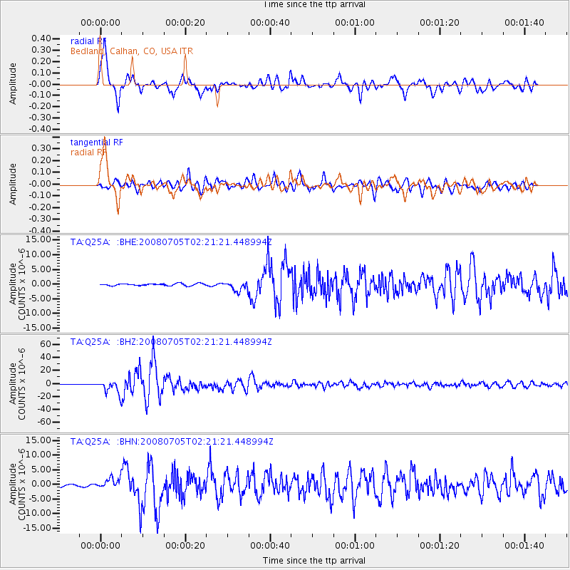
Signal To Noise
| Channel | StoN | STA | LTA |
| TA:Q25A: :BHZ:20080705T02:21:21.448994Z | 44.970806 | 9.825766E-6 | 2.184921E-7 |
| TA:Q25A: :BHN:20080705T02:21:21.448994Z | 5.4264607 | 1.8560523E-6 | 3.4203737E-7 |
| TA:Q25A: :BHE:20080705T02:21:21.448994Z | 4.836153 | 1.6724322E-6 | 3.458187E-7 |
| Arrivals |
| Ps | 6.6 SECOND |
| PpPs | 20 SECOND |
| PsPs/PpSs | 26 SECOND |


