You are here: Home > Network List > TA - USArray Transportable Network (new EarthScope stations) Stations List
> Station Q25A Bedland, Calhan, CO, USA > Earthquake Result Viewer
Q25A Bedland, Calhan, CO, USA - Earthquake Result Viewer
| Earthquake location: |
Off East Coast Of Honshu, Japan |
| Earthquake latitude/longitude: |
37.6/142.2 |
| Earthquake time(UTC): |
2008/07/19 (201) 02:39:28 GMT |
| Earthquake Depth: |
22 km |
| Earthquake Magnitude: |
6.2 MB, 7.0 MS, 7.0 MW, 6.9 MW |
| Earthquake Catalog/Contributor: |
WHDF/NEIC |
|
| Network: |
TA USArray Transportable Network (new EarthScope stations) |
| Station: |
Q25A Bedland, Calhan, CO, USA |
| Lat/Lon: |
38.91 N/104.25 W |
| Elevation: |
2001 m |
|
| Distance: |
82.4 deg |
| Az: |
46.182 deg |
| Baz: |
312.686 deg |
| Ray Param: |
0.046884034 |
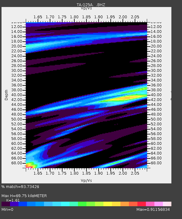
| Estimated Moho Depth: |
69.75 km |
| Estimated Crust Vp/Vs: |
1.61 |
| Assumed Crust Vp: |
6.159 km/s |
| Estimated Crust Vs: |
3.825 km/s |
| Estimated Crust Poisson's Ratio: |
0.19 |
|
| Radial Match: |
93.73426 % |
| Radial Bump: |
326 |
| Transverse Match: |
83.89047 % |
| Transverse Bump: |
400 |
| SOD ConfigId: |
2504 |
| Insert Time: |
2010-03-06 03:06:01.384 +0000 |
| GWidth: |
2.5 |
| Max Bumps: |
400 |
| Tol: |
0.001 |
|
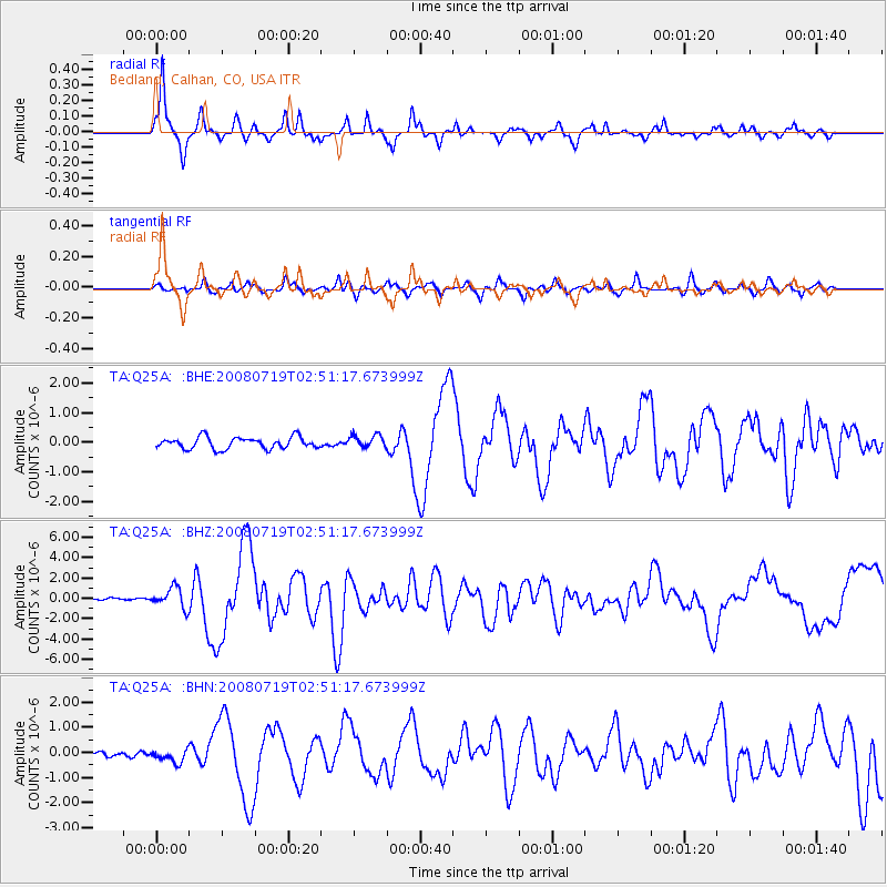
Signal To Noise
| Channel | StoN | STA | LTA |
| TA:Q25A: :BHZ:20080719T02:51:17.673999Z | 10.365542 | 1.0049085E-6 | 9.6947026E-8 |
| TA:Q25A: :BHN:20080719T02:51:17.673999Z | 2.610344 | 2.4928917E-7 | 9.55005E-8 |
| TA:Q25A: :BHE:20080719T02:51:17.673999Z | 1.0925326 | 2.1383019E-7 | 1.9571974E-7 |
| Arrivals |
| Ps | 7.1 SECOND |
| PpPs | 29 SECOND |
| PsPs/PpSs | 36 SECOND |


