You are here: Home > Network List > UU - University of Utah Regional Network Stations List
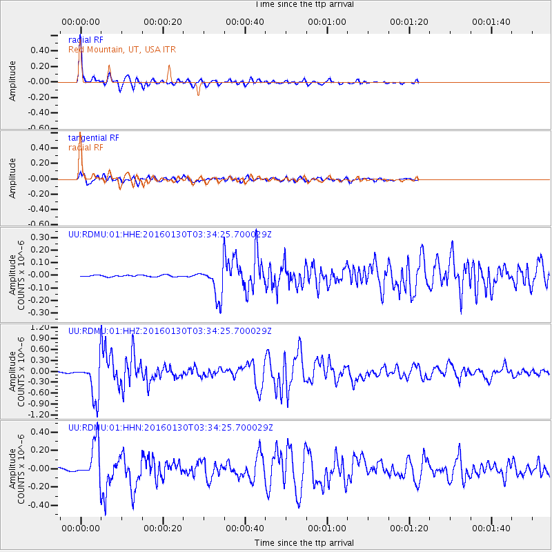
> Station RDMU Red Mountain, UT, USA > Earthquake Result Viewer
RDMU Red Mountain, UT, USA - Earthquake Result Viewer
| Earthquake location: |
Kamchatka Peninsula, Russia |
| Earthquake latitude/longitude: |
54.0/158.5 |
| Earthquake time(UTC): |
2016/01/30 (030) 03:25:10 GMT |
| Earthquake Depth: |
161 km |
| Earthquake Magnitude: |
7.2 MWW, 7.0 MI, 7.2 MWB |
| Earthquake Catalog/Contributor: |
NEIC PDE/NEIC COMCAT |
|
| Network: |
UU University of Utah Regional Network |
| Station: |
RDMU Red Mountain, UT, USA |
| Lat/Lon: |
40.57 N/109.57 W |
| Elevation: |
2087 m |
|
| Distance: |
59.5 deg |
| Az: |
62.102 deg |
| Baz: |
316.778 deg |
| Ray Param: |
0.06165927 |
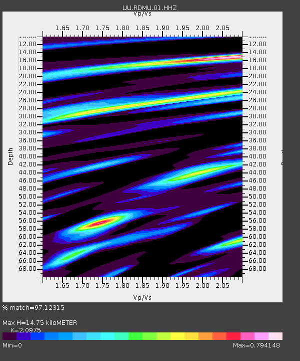
| Estimated Moho Depth: |
14.75 km |
| Estimated Crust Vp/Vs: |
2.10 |
| Assumed Crust Vp: |
6.207 km/s |
| Estimated Crust Vs: |
2.959 km/s |
| Estimated Crust Poisson's Ratio: |
0.35 |
|
| Radial Match: |
97.12315 % |
| Radial Bump: |
306 |
| Transverse Match: |
90.237335 % |
| Transverse Bump: |
400 |
| SOD ConfigId: |
1427151 |
| Insert Time: |
2016-02-13 04:21:52.933 +0000 |
| GWidth: |
2.5 |
| Max Bumps: |
400 |
| Tol: |
0.001 |
|
Signal To Noise
| Channel | StoN | STA | LTA |
| UU:RDMU:01:HHZ:20160130T03:34:25.700029Z | 41.331055 | 5.2418807E-7 | 1.2682668E-8 |
| UU:RDMU:01:HHN:20160130T03:34:25.700029Z | 17.264023 | 2.0969391E-7 | 1.21462955E-8 |
| UU:RDMU:01:HHE:20160130T03:34:25.700029Z | 21.3272 | 1.3325383E-7 | 6.2480696E-9 |
| Arrivals |
| Ps | 2.7 SECOND |
| PpPs | 7.1 SECOND |
| PsPs/PpSs | 9.8 SECOND |


