You are here: Home > Network List > TA - USArray Transportable Network (new EarthScope stations) Stations List
> Station Q25A Bedland, Calhan, CO, USA > Earthquake Result Viewer
Q25A Bedland, Calhan, CO, USA - Earthquake Result Viewer
| Earthquake location: |
Central Mid-Atlantic Ridge |
| Earthquake latitude/longitude: |
8.1/-38.7 |
| Earthquake time(UTC): |
2008/09/10 (254) 13:08:14 GMT |
| Earthquake Depth: |
10 km |
| Earthquake Magnitude: |
6.3 MB, 6.5 MS, 6.6 MW, 6.6 MW |
| Earthquake Catalog/Contributor: |
WHDF/NEIC |
|
| Network: |
TA USArray Transportable Network (new EarthScope stations) |
| Station: |
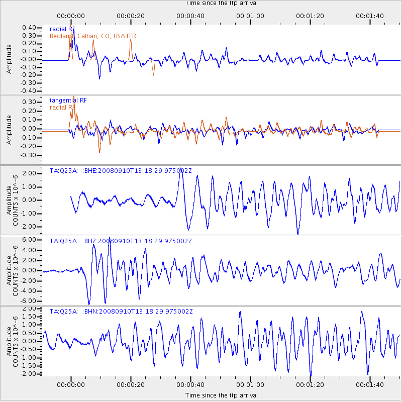
Q25A Bedland, Calhan, CO, USA |
| Lat/Lon: |
38.91 N/104.25 W |
| Elevation: |
2001 m |
|
| Distance: |
66.0 deg |
| Az: |
308.964 deg |
| Baz: |
99.295 deg |
| Ray Param: |
0.05793285 |
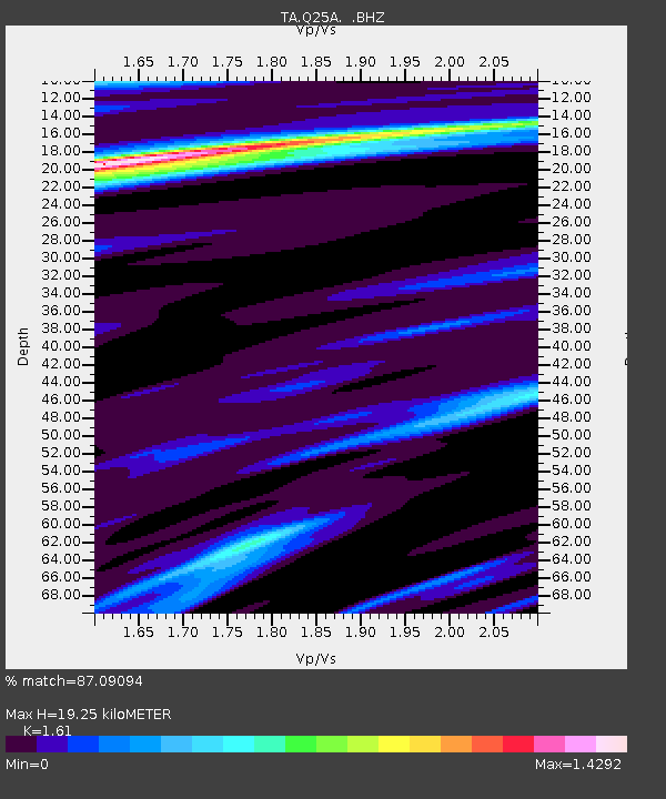
| Estimated Moho Depth: |
19.25 km |
| Estimated Crust Vp/Vs: |
1.61 |
| Assumed Crust Vp: |
6.159 km/s |
| Estimated Crust Vs: |
3.825 km/s |
| Estimated Crust Poisson's Ratio: |
0.19 |
|
| Radial Match: |
87.09094 % |
| Radial Bump: |
400 |
| Transverse Match: |
76.65183 % |
| Transverse Bump: |
400 |
| SOD ConfigId: |
2560 |
| Insert Time: |
2010-03-06 03:06:12.119 +0000 |
| GWidth: |
2.5 |
| Max Bumps: |
400 |
| Tol: |
0.001 |
|
Signal To Noise
| Channel | StoN | STA | LTA |
| TA:Q25A: :BHZ:20080910T13:18:29.975002Z | 2.8983824 | 3.4234756E-7 | 1.1811677E-7 |
| TA:Q25A: :BHN:20080910T13:18:29.975002Z | 0.5464521 | 1.5152412E-7 | 2.772871E-7 |
| TA:Q25A: :BHE:20080910T13:18:29.975002Z | 0.7876562 | 2.2538933E-7 | 2.861519E-7 |
| Arrivals |
| Ps | 2.0 SECOND |
| PpPs | 7.8 SECOND |
| PsPs/PpSs | 9.8 SECOND |


