You are here: Home > Network List > TA - USArray Transportable Network (new EarthScope stations) Stations List
> Station Q25A Bedland, Calhan, CO, USA > Earthquake Result Viewer
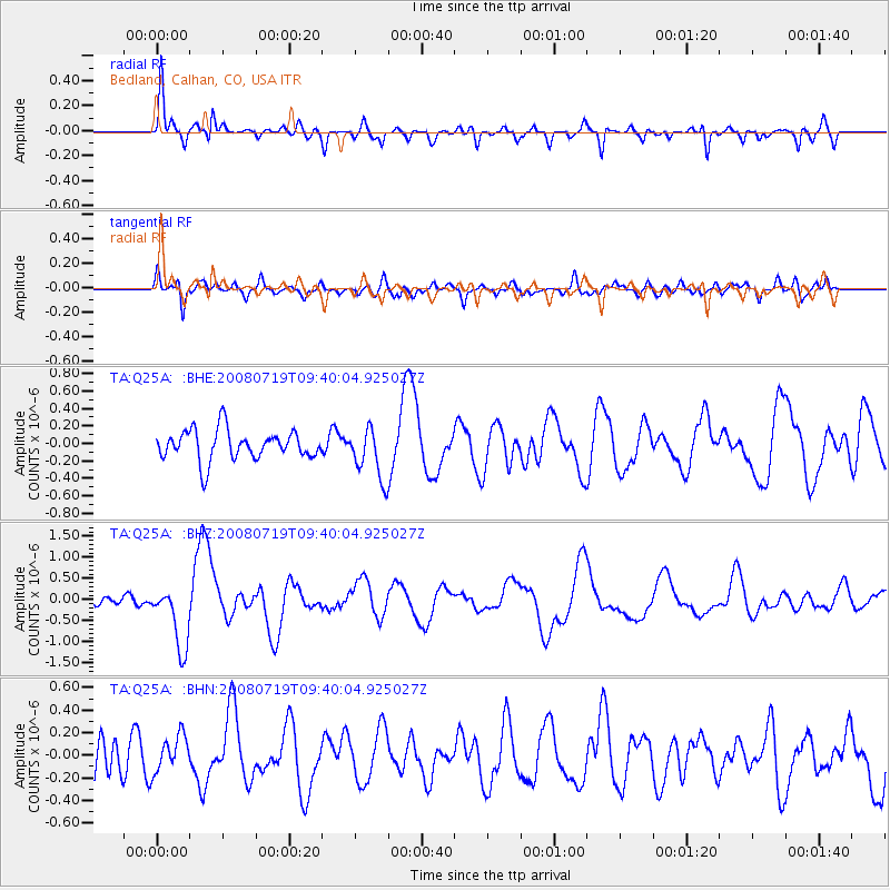
Q25A Bedland, Calhan, CO, USA - Earthquake Result Viewer

| Earthquake location: |
Santa Cruz Islands Region |
| Earthquake latitude/longitude: |
-11.0/164.5 |
| Earthquake time(UTC): |
2008/07/19 (201) 09:27:01 GMT |
| Earthquake Depth: |
11 km |
| Earthquake Magnitude: |
6.1 MB, 6.4 MS, 6.6 MW, 6.6 MW |
| Earthquake Catalog/Contributor: |
WHDF/NEIC |
|
| Network: |
TA USArray Transportable Network (new EarthScope stations) |
| Station: |
Q25A Bedland, Calhan, CO, USA |
| Lat/Lon: |
38.91 N/104.25 W |
| Elevation: |
2001 m |
|
| Distance: |
97.8 deg |
| Az: |
51.93 deg |
| Baz: |
262.172 deg |
| Ray Param: |
0.04010077 |
| Estimated Moho Depth: |
67.5 km |
| Estimated Crust Vp/Vs: |
1.91 |
| Assumed Crust Vp: |
6.159 km/s |
| Estimated Crust Vs: |
3.216 km/s |
| Estimated Crust Poisson's Ratio: |
0.31 |
|
| Radial Match: |
84.617096 % |
| Radial Bump: |
345 |
| Transverse Match: |
66.75025 % |
| Transverse Bump: |
400 |
| SOD ConfigId: |
2658 |
| Insert Time: |
2010-03-06 03:06:15.590 +0000 |
| GWidth: |
2.5 |
| Max Bumps: |
400 |
| Tol: |
0.001 |
|
Signal To Noise
| Channel | StoN | STA | LTA |
| TA:Q25A: :BHZ:20080719T09:40:04.925027Z | 9.333657 | 7.5332963E-7 | 8.071108E-8 |
| TA:Q25A: :BHN:20080719T09:40:04.925027Z | 1.0217805 | 1.6024923E-7 | 1.5683332E-7 |
| TA:Q25A: :BHE:20080719T09:40:04.925027Z | 1.7157655 | 2.94373E-7 | 1.7156948E-7 |
| Arrivals |
| Ps | 10 SECOND |
| PpPs | 31 SECOND |
| PsPs/PpSs | 42 SECOND |


