You are here: Home > Network List > TA - USArray Transportable Network (new EarthScope stations) Stations List
> Station Q25A Bedland, Calhan, CO, USA > Earthquake Result Viewer
Q25A Bedland, Calhan, CO, USA - Earthquake Result Viewer
| Earthquake location: |
Near S. Coast Of Honshu, Japan |
| Earthquake latitude/longitude: |
33.2/137.9 |
| Earthquake time(UTC): |
2009/08/09 (221) 10:55:55 GMT |
| Earthquake Depth: |
297 km |
| Earthquake Magnitude: |
6.5 MB, 7.1 MW, 7.1 MW |
| Earthquake Catalog/Contributor: |
WHDF/NEIC |
|
| Network: |
TA USArray Transportable Network (new EarthScope stations) |
| Station: |
Q25A Bedland, Calhan, CO, USA |
| Lat/Lon: |
38.91 N/104.25 W |
| Elevation: |
2001 m |
|
| Distance: |
88.0 deg |
| Az: |
43.666 deg |
| Baz: |
312.07 deg |
| Ray Param: |
0.0421984 |
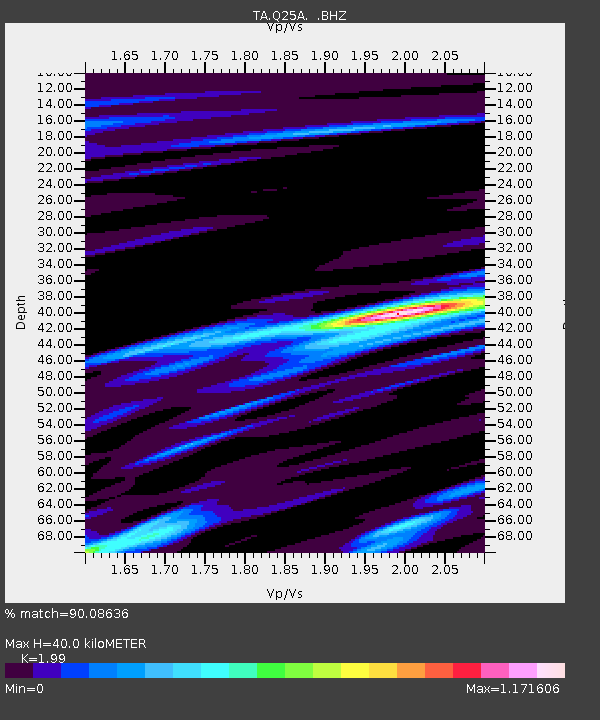
| Estimated Moho Depth: |
40.0 km |
| Estimated Crust Vp/Vs: |
1.99 |
| Assumed Crust Vp: |
6.159 km/s |
| Estimated Crust Vs: |
3.095 km/s |
| Estimated Crust Poisson's Ratio: |
0.33 |
|
| Radial Match: |
90.08636 % |
| Radial Bump: |
400 |
| Transverse Match: |
76.3237 % |
| Transverse Bump: |
400 |
| SOD ConfigId: |
2622 |
| Insert Time: |
2010-03-06 03:06:20.272 +0000 |
| GWidth: |
2.5 |
| Max Bumps: |
400 |
| Tol: |
0.001 |
|
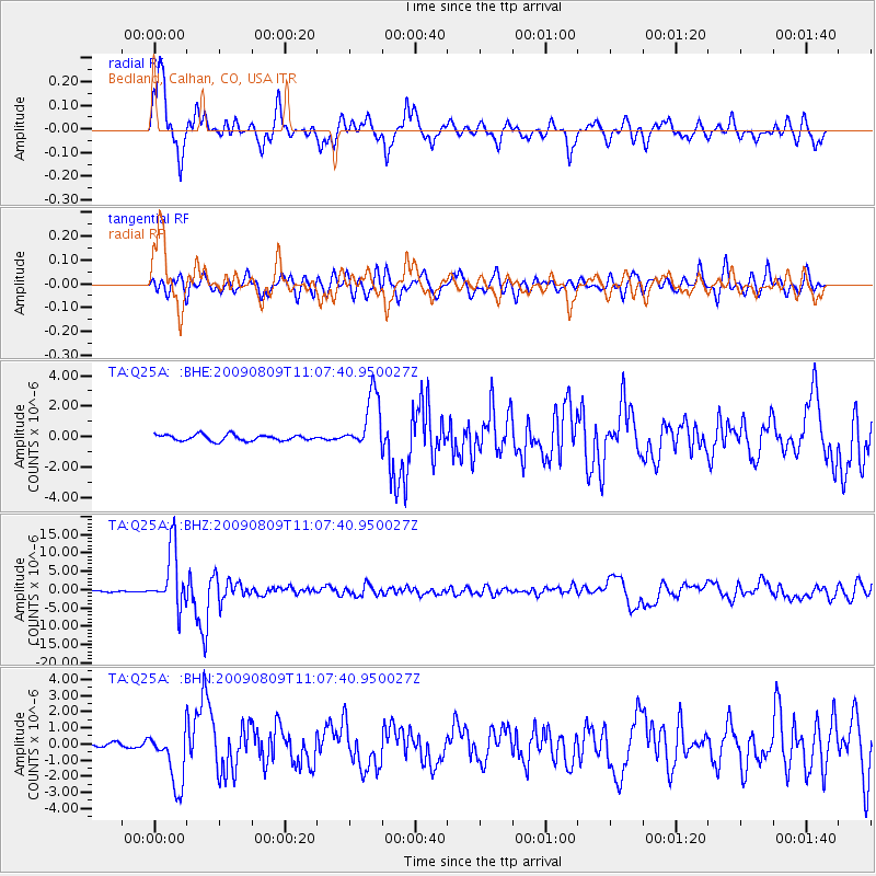
Signal To Noise
| Channel | StoN | STA | LTA |
| TA:Q25A: :BHZ:20090809T11:07:40.950027Z | 71.25528 | 7.992738E-6 | 1.1217047E-7 |
| TA:Q25A: :BHN:20090809T11:07:40.950027Z | 9.794104 | 1.7479174E-6 | 1.784663E-7 |
| TA:Q25A: :BHE:20090809T11:07:40.950027Z | 9.313195 | 1.8489142E-6 | 1.985263E-7 |
| Arrivals |
| Ps | 6.5 SECOND |
| PpPs | 19 SECOND |
| PsPs/PpSs | 26 SECOND |


