You are here: Home > Network List > TA - USArray Transportable Network (new EarthScope stations) Stations List
> Station F21K Alatna River, AK, USA > Earthquake Result Viewer
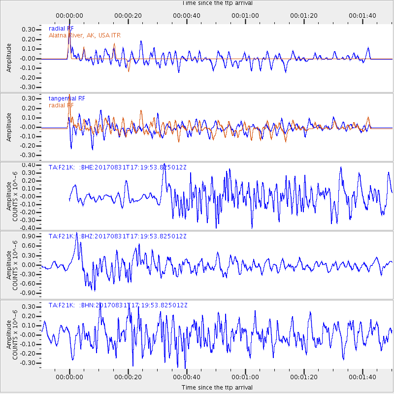
F21K Alatna River, AK, USA - Earthquake Result Viewer
*The percent match for this event was below the threshold and hence no stack was calculated.
| Earthquake location: |
Southern Sumatra, Indonesia |
| Earthquake latitude/longitude: |
-1.2/99.7 |
| Earthquake time(UTC): |
2017/08/31 (243) 17:06:55 GMT |
| Earthquake Depth: |
43 km |
| Earthquake Magnitude: |
6.3 Mww |
| Earthquake Catalog/Contributor: |
NEIC PDE/us |
|
| Network: |
TA USArray Transportable Network (new EarthScope stations) |
| Station: |
F21K Alatna River, AK, USA |
| Lat/Lon: |
67.22 N/153.48 W |
| Elevation: |
597 m |
|
| Distance: |
97.5 deg |
| Az: |
22.083 deg |
| Baz: |
285.132 deg |
| Ray Param: |
$rayparam |
*The percent match for this event was below the threshold and hence was not used in the summary stack. |
|
| Radial Match: |
71.116196 % |
| Radial Bump: |
400 |
| Transverse Match: |
69.01727 % |
| Transverse Bump: |
400 |
| SOD ConfigId: |
13570011 |
| Insert Time: |
2019-04-28 15:53:23.781 +0000 |
| GWidth: |
2.5 |
| Max Bumps: |
400 |
| Tol: |
0.001 |
|
Signal To Noise
| Channel | StoN | STA | LTA |
| TA:F21K: :BHZ:20170831T17:19:53.825012Z | 8.804799 | 4.6602472E-7 | 5.292849E-8 |
| TA:F21K: :BHN:20170831T17:19:53.825012Z | 1.9019281 | 1.2050094E-7 | 6.3357255E-8 |
| TA:F21K: :BHE:20170831T17:19:53.825012Z | 2.7986684 | 1.8300086E-7 | 6.5388555E-8 |
| Arrivals |
| Ps | |
| PpPs | |
| PsPs/PpSs | |


