You are here: Home > Network List > TA - USArray Transportable Network (new EarthScope stations) Stations List
> Station I17K Unalakleet, AK, USA > Earthquake Result Viewer
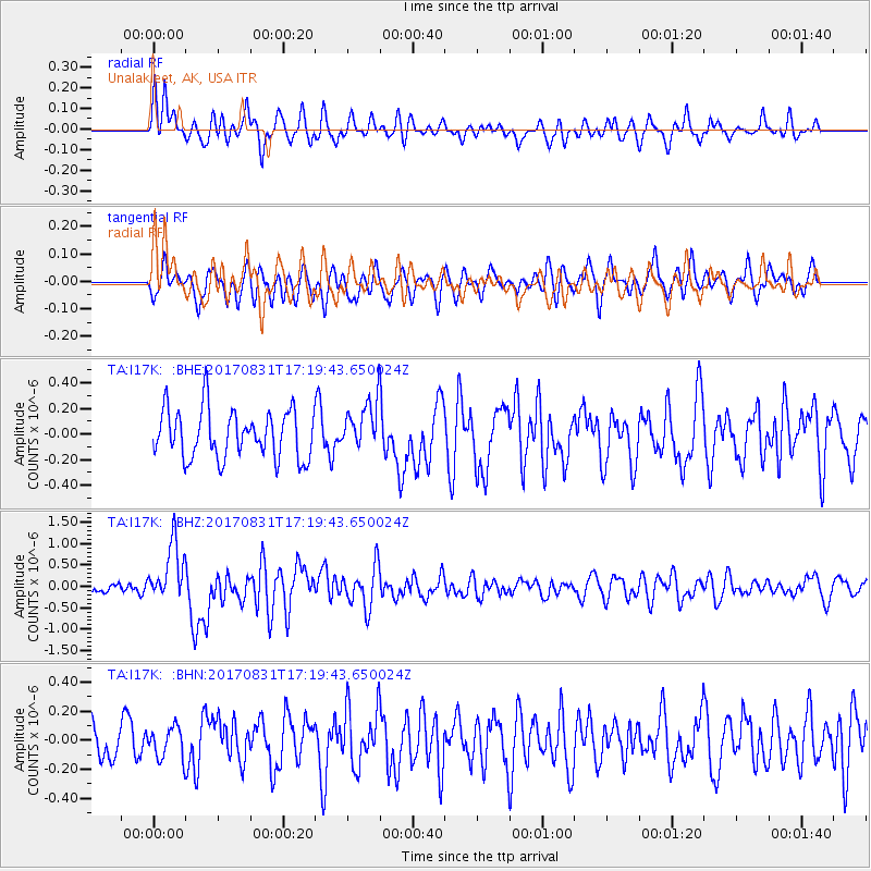
I17K Unalakleet, AK, USA - Earthquake Result Viewer
*The percent match for this event was below the threshold and hence no stack was calculated.
| Earthquake location: |
Southern Sumatra, Indonesia |
| Earthquake latitude/longitude: |
-1.2/99.7 |
| Earthquake time(UTC): |
2017/08/31 (243) 17:06:55 GMT |
| Earthquake Depth: |
43 km |
| Earthquake Magnitude: |
6.3 Mww |
| Earthquake Catalog/Contributor: |
NEIC PDE/us |
|
| Network: |
TA USArray Transportable Network (new EarthScope stations) |
| Station: |
I17K Unalakleet, AK, USA |
| Lat/Lon: |
63.89 N/160.70 W |
| Elevation: |
105 m |
|
| Distance: |
95.3 deg |
| Az: |
25.988 deg |
| Baz: |
278.134 deg |
| Ray Param: |
$rayparam |
*The percent match for this event was below the threshold and hence was not used in the summary stack. |
|
| Radial Match: |
61.72547 % |
| Radial Bump: |
400 |
| Transverse Match: |
57.775177 % |
| Transverse Bump: |
400 |
| SOD ConfigId: |
13570011 |
| Insert Time: |
2019-04-28 15:53:34.877 +0000 |
| GWidth: |
2.5 |
| Max Bumps: |
400 |
| Tol: |
0.001 |
|
Signal To Noise
| Channel | StoN | STA | LTA |
| TA:I17K: :BHZ:20170831T17:19:43.650024Z | 4.6967707 | 6.7706253E-7 | 1.441549E-7 |
| TA:I17K: :BHN:20170831T17:19:43.650024Z | 0.6529227 | 1.080327E-7 | 1.6546018E-7 |
| TA:I17K: :BHE:20170831T17:19:43.650024Z | 1.0137515 | 1.922357E-7 | 1.8962803E-7 |
| Arrivals |
| Ps | |
| PpPs | |
| PsPs/PpSs | |


