You are here: Home > Network List > TA - USArray Transportable Network (new EarthScope stations) Stations List
> Station Q25A Bedland, Calhan, CO, USA > Earthquake Result Viewer
Q25A Bedland, Calhan, CO, USA - Earthquake Result Viewer
| Earthquake location: |
North Of Svalbard |
| Earthquake latitude/longitude: |
80.3/-1.9 |
| Earthquake time(UTC): |
2009/03/06 (065) 10:50:29 GMT |
| Earthquake Depth: |
9.0 km |
| Earthquake Magnitude: |
6.6 MB, 6.5 MS, 6.5 MW, 6.4 MW |
| Earthquake Catalog/Contributor: |
WHDF/NEIC |
|
| Network: |
TA USArray Transportable Network (new EarthScope stations) |
| Station: |
Q25A Bedland, Calhan, CO, USA |
| Lat/Lon: |
38.91 N/104.25 W |
| Elevation: |
2001 m |
|
| Distance: |
54.0 deg |
| Az: |
289.57 deg |
| Baz: |
11.79 deg |
| Ray Param: |
0.06574813 |
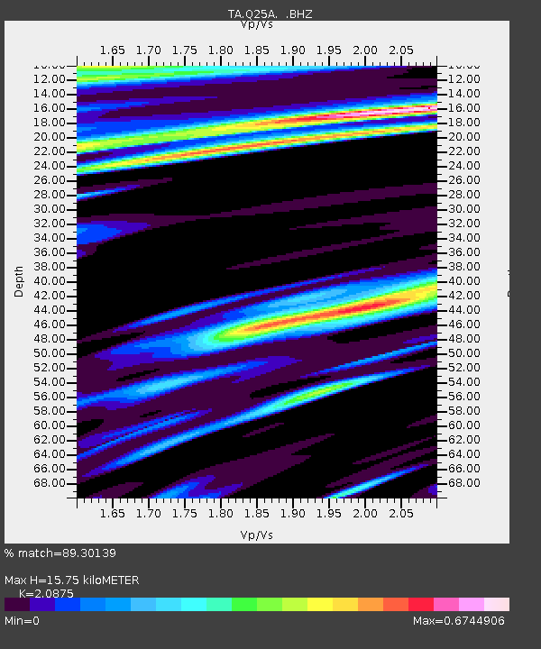
| Estimated Moho Depth: |
15.75 km |
| Estimated Crust Vp/Vs: |
2.09 |
| Assumed Crust Vp: |
6.159 km/s |
| Estimated Crust Vs: |
2.95 km/s |
| Estimated Crust Poisson's Ratio: |
0.35 |
|
| Radial Match: |
89.30139 % |
| Radial Bump: |
400 |
| Transverse Match: |
82.76973 % |
| Transverse Bump: |
400 |
| SOD ConfigId: |
2658 |
| Insert Time: |
2010-03-06 03:06:31.163 +0000 |
| GWidth: |
2.5 |
| Max Bumps: |
400 |
| Tol: |
0.001 |
|
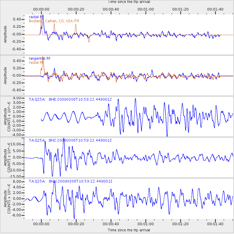
Signal To Noise
| Channel | StoN | STA | LTA |
| TA:Q25A: :BHZ:20090306T10:59:22.449001Z | 27.749208 | 5.7358347E-6 | 2.0670264E-7 |
| TA:Q25A: :BHN:20090306T10:59:22.449001Z | 6.9180207 | 2.3863256E-6 | 3.4494343E-7 |
| TA:Q25A: :BHE:20090306T10:59:22.449001Z | 0.6906955 | 4.6810356E-7 | 6.777278E-7 |
| Arrivals |
| Ps | 2.9 SECOND |
| PpPs | 7.6 SECOND |
| PsPs/PpSs | 10 SECOND |


