You are here: Home > Network List > TA - USArray Transportable Network (new EarthScope stations) Stations List
> Station Q25A Bedland, Calhan, CO, USA > Earthquake Result Viewer
Q25A Bedland, Calhan, CO, USA - Earthquake Result Viewer
| Earthquake location: |
Rat Islands, Aleutian Islands |
| Earthquake latitude/longitude: |
50.4/177.0 |
| Earthquake time(UTC): |
2009/07/06 (187) 14:53:12 GMT |
| Earthquake Depth: |
22 km |
| Earthquake Magnitude: |
6.0 MB, 5.8 MS, 6.1 MW, 6.0 MW |
| Earthquake Catalog/Contributor: |
WHDF/NEIC |
|
| Network: |
TA USArray Transportable Network (new EarthScope stations) |
| Station: |
Q25A Bedland, Calhan, CO, USA |
| Lat/Lon: |
38.91 N/104.25 W |
| Elevation: |
2001 m |
|
| Distance: |
54.7 deg |
| Az: |
69.692 deg |
| Baz: |
309.757 deg |
| Ray Param: |
0.06527024 |
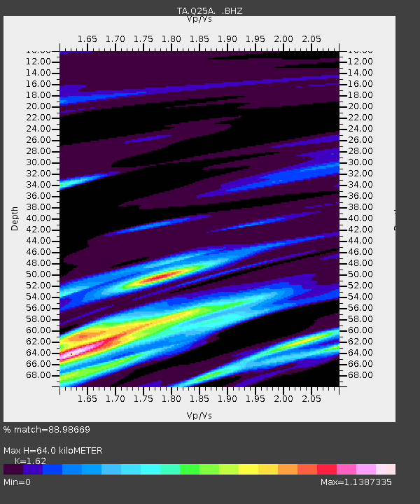
| Estimated Moho Depth: |
64.0 km |
| Estimated Crust Vp/Vs: |
1.62 |
| Assumed Crust Vp: |
6.159 km/s |
| Estimated Crust Vs: |
3.802 km/s |
| Estimated Crust Poisson's Ratio: |
0.19 |
|
| Radial Match: |
88.98669 % |
| Radial Bump: |
400 |
| Transverse Match: |
78.884026 % |
| Transverse Bump: |
400 |
| SOD ConfigId: |
2648 |
| Insert Time: |
2010-03-06 03:06:36.638 +0000 |
| GWidth: |
2.5 |
| Max Bumps: |
400 |
| Tol: |
0.001 |
|
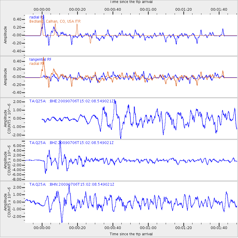
Signal To Noise
| Channel | StoN | STA | LTA |
| TA:Q25A: :BHZ:20090706T15:02:08.549021Z | 8.944721 | 2.343386E-6 | 2.6198538E-7 |
| TA:Q25A: :BHN:20090706T15:02:08.549021Z | 2.260924 | 6.3241833E-7 | 2.7971674E-7 |
| TA:Q25A: :BHE:20090706T15:02:08.549021Z | 3.8382885 | 7.2116273E-7 | 1.8788654E-7 |
| Arrivals |
| Ps | 6.8 SECOND |
| PpPs | 26 SECOND |
| PsPs/PpSs | 33 SECOND |


