You are here: Home > Network List > AZ - ANZA Regional Network Stations List
> Station SMER AZ.SMER > Earthquake Result Viewer
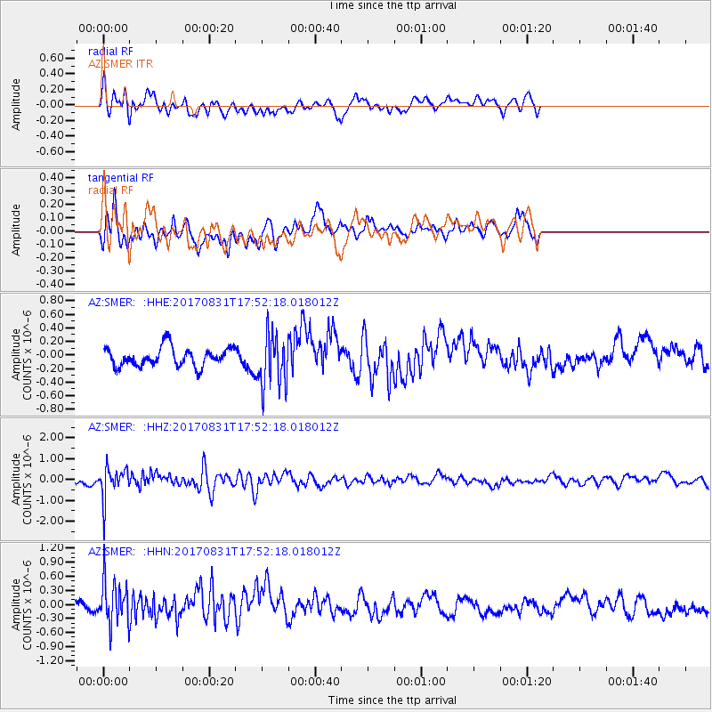
SMER AZ.SMER - Earthquake Result Viewer
*The percent match for this event was below the threshold and hence no stack was calculated.
| Earthquake location: |
Kodiak Island Region, Alaska |
| Earthquake latitude/longitude: |
58.5/-153.7 |
| Earthquake time(UTC): |
2017/08/31 (243) 17:46:02 GMT |
| Earthquake Depth: |
62 km |
| Earthquake Magnitude: |
5.5 ml |
| Earthquake Catalog/Contributor: |
NEIC PDE/ak |
|
| Network: |
AZ ANZA Regional Network |
| Station: |
SMER AZ.SMER |
| Lat/Lon: |
33.46 N/117.17 W |
| Elevation: |
355 m |
|
| Distance: |
34.9 deg |
| Az: |
119.679 deg |
| Baz: |
326.878 deg |
| Ray Param: |
$rayparam |
*The percent match for this event was below the threshold and hence was not used in the summary stack. |
|
| Radial Match: |
57.722076 % |
| Radial Bump: |
400 |
| Transverse Match: |
54.079895 % |
| Transverse Bump: |
400 |
| SOD ConfigId: |
13570011 |
| Insert Time: |
2019-04-28 15:55:02.345 +0000 |
| GWidth: |
2.5 |
| Max Bumps: |
400 |
| Tol: |
0.001 |
|
Signal To Noise
| Channel | StoN | STA | LTA |
| AZ:SMER: :HHZ:20170831T17:52:18.018012Z | 3.05175 | 7.489412E-7 | 2.454137E-7 |
| AZ:SMER: :HHN:20170831T17:52:18.018012Z | 3.470491 | 4.70647E-7 | 1.3561396E-7 |
| AZ:SMER: :HHE:20170831T17:52:18.018012Z | 2.7957308 | 3.8617685E-7 | 1.3813091E-7 |
| Arrivals |
| Ps | |
| PpPs | |
| PsPs/PpSs | |


