You are here: Home > Network List > CI - Caltech Regional Seismic Network Stations List
> Station MPM Manuel Prospect Mine, California, USA > Earthquake Result Viewer
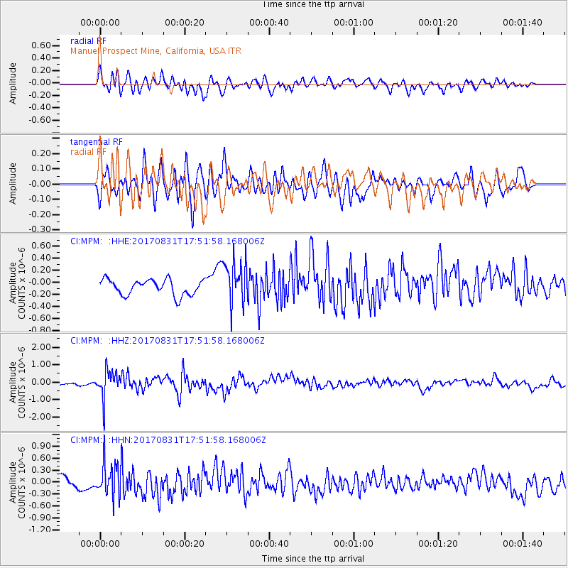
MPM Manuel Prospect Mine, California, USA - Earthquake Result Viewer
*The percent match for this event was below the threshold and hence no stack was calculated.
| Earthquake location: |
Kodiak Island Region, Alaska |
| Earthquake latitude/longitude: |
58.5/-153.7 |
| Earthquake time(UTC): |
2017/08/31 (243) 17:46:02 GMT |
| Earthquake Depth: |
62 km |
| Earthquake Magnitude: |
5.5 ml |
| Earthquake Catalog/Contributor: |
NEIC PDE/ak |
|
| Network: |
CI Caltech Regional Seismic Network |
| Station: |
MPM Manuel Prospect Mine, California, USA |
| Lat/Lon: |
36.06 N/117.49 W |
| Elevation: |
185 m |
|
| Distance: |
32.6 deg |
| Az: |
117.449 deg |
| Baz: |
324.842 deg |
| Ray Param: |
$rayparam |
*The percent match for this event was below the threshold and hence was not used in the summary stack. |
|
| Radial Match: |
69.27281 % |
| Radial Bump: |
400 |
| Transverse Match: |
67.68946 % |
| Transverse Bump: |
400 |
| SOD ConfigId: |
13570011 |
| Insert Time: |
2019-04-28 15:55:48.103 +0000 |
| GWidth: |
2.5 |
| Max Bumps: |
400 |
| Tol: |
0.001 |
|
Signal To Noise
| Channel | StoN | STA | LTA |
| CI:MPM: :HHZ:20170831T17:51:58.168006Z | 10.7759285 | 7.9251555E-7 | 7.354499E-8 |
| CI:MPM: :HHN:20170831T17:51:58.168006Z | 2.8301797 | 4.0670258E-7 | 1.4370202E-7 |
| CI:MPM: :HHE:20170831T17:51:58.168006Z | 2.8534236 | 3.6647816E-7 | 1.2843455E-7 |
| Arrivals |
| Ps | |
| PpPs | |
| PsPs/PpSs | |


