You are here: Home > Network List > CI - Caltech Regional Seismic Network Stations List
> Station MUR Murrieta > Earthquake Result Viewer
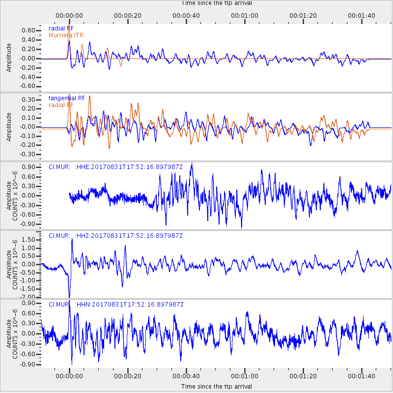
MUR Murrieta - Earthquake Result Viewer
*The percent match for this event was below the threshold and hence no stack was calculated.
| Earthquake location: |
Kodiak Island Region, Alaska |
| Earthquake latitude/longitude: |
58.5/-153.7 |
| Earthquake time(UTC): |
2017/08/31 (243) 17:46:02 GMT |
| Earthquake Depth: |
62 km |
| Earthquake Magnitude: |
5.5 ml |
| Earthquake Catalog/Contributor: |
NEIC PDE/ak |
|
| Network: |
CI Caltech Regional Seismic Network |
| Station: |
MUR Murrieta |
| Lat/Lon: |
33.60 N/117.20 W |
| Elevation: |
562 m |
|
| Distance: |
34.8 deg |
| Az: |
119.574 deg |
| Baz: |
326.778 deg |
| Ray Param: |
$rayparam |
*The percent match for this event was below the threshold and hence was not used in the summary stack. |
|
| Radial Match: |
60.192524 % |
| Radial Bump: |
400 |
| Transverse Match: |
57.602596 % |
| Transverse Bump: |
400 |
| SOD ConfigId: |
13570011 |
| Insert Time: |
2019-04-28 15:55:48.441 +0000 |
| GWidth: |
2.5 |
| Max Bumps: |
400 |
| Tol: |
0.001 |
|
Signal To Noise
| Channel | StoN | STA | LTA |
| CI:MUR: :HHZ:20170831T17:52:16.897987Z | 2.8520222 | 7.8181347E-7 | 2.7412602E-7 |
| CI:MUR: :HHN:20170831T17:52:16.897987Z | 3.3538604 | 4.1541824E-7 | 1.238627E-7 |
| CI:MUR: :HHE:20170831T17:52:16.897987Z | 2.7330809 | 3.368942E-7 | 1.2326535E-7 |
| Arrivals |
| Ps | |
| PpPs | |
| PsPs/PpSs | |


