You are here: Home > Network List > ZW13 - Locating North Texas Earthquakes Stations List
> Station IFCF Coppell Firestation > Earthquake Result Viewer
IFCF Coppell Firestation - Earthquake Result Viewer
| Earthquake location: |
Kamchatka Peninsula, Russia |
| Earthquake latitude/longitude: |
54.0/158.5 |
| Earthquake time(UTC): |
2016/01/30 (030) 03:25:10 GMT |
| Earthquake Depth: |
161 km |
| Earthquake Magnitude: |
7.2 MWW, 7.0 MI, 7.2 MWB |
| Earthquake Catalog/Contributor: |
NEIC PDE/NEIC COMCAT |
|
| Network: |
ZW Locating North Texas Earthquakes |
| Station: |
IFCF Coppell Firestation |
| Lat/Lon: |
32.96 N/96.96 W |
| Elevation: |
136 m |
|
| Distance: |
71.8 deg |
| Az: |
58.951 deg |
| Baz: |
323.021 deg |
| Ray Param: |
0.053665012 |
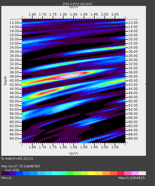
| Estimated Moho Depth: |
37.75 km |
| Estimated Crust Vp/Vs: |
1.84 |
| Assumed Crust Vp: |
6.38 km/s |
| Estimated Crust Vs: |
3.477 km/s |
| Estimated Crust Poisson's Ratio: |
0.29 |
|
| Radial Match: |
85.32121 % |
| Radial Bump: |
400 |
| Transverse Match: |
68.08139 % |
| Transverse Bump: |
400 |
| SOD ConfigId: |
1427151 |
| Insert Time: |
2016-02-13 04:23:26.748 +0000 |
| GWidth: |
2.5 |
| Max Bumps: |
400 |
| Tol: |
0.001 |
|

Signal To Noise
| Channel | StoN | STA | LTA |
| ZW:IFCF:00:HHZ:20160130T03:35:44.365007Z | 16.993668 | 3.5158007E-7 | 2.0688889E-8 |
| ZW:IFCF:00:HH1:20160130T03:35:44.365007Z | 2.526042 | 1.3618093E-7 | 5.3910796E-8 |
| ZW:IFCF:00:HH2:20160130T03:35:44.365007Z | 1.8451716 | 8.3381316E-8 | 4.5188923E-8 |
| Arrivals |
| Ps | 5.1 SECOND |
| PpPs | 16 SECOND |
| PsPs/PpSs | 21 SECOND |


