You are here: Home > Network List > CI - Caltech Regional Seismic Network Stations List
> Station TIN Tinemaha, Big Pine, CA, USA > Earthquake Result Viewer
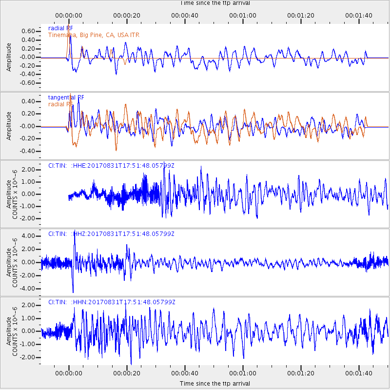
TIN Tinemaha, Big Pine, CA, USA - Earthquake Result Viewer
*The percent match for this event was below the threshold and hence no stack was calculated.
| Earthquake location: |
Kodiak Island Region, Alaska |
| Earthquake latitude/longitude: |
58.5/-153.7 |
| Earthquake time(UTC): |
2017/08/31 (243) 17:46:02 GMT |
| Earthquake Depth: |
62 km |
| Earthquake Magnitude: |
5.5 ml |
| Earthquake Catalog/Contributor: |
NEIC PDE/ak |
|
| Network: |
CI Caltech Regional Seismic Network |
| Station: |
TIN Tinemaha, Big Pine, CA, USA |
| Lat/Lon: |
37.05 N/118.23 W |
| Elevation: |
1197 m |
|
| Distance: |
31.4 deg |
| Az: |
117.278 deg |
| Baz: |
324.258 deg |
| Ray Param: |
$rayparam |
*The percent match for this event was below the threshold and hence was not used in the summary stack. |
|
| Radial Match: |
77.96318 % |
| Radial Bump: |
400 |
| Transverse Match: |
69.19287 % |
| Transverse Bump: |
400 |
| SOD ConfigId: |
13570011 |
| Insert Time: |
2019-04-28 15:56:05.713 +0000 |
| GWidth: |
2.5 |
| Max Bumps: |
400 |
| Tol: |
0.001 |
|
Signal To Noise
| Channel | StoN | STA | LTA |
| CI:TIN: :HHZ:20170831T17:51:48.05799Z | 3.733123 | 1.5208083E-6 | 4.0738232E-7 |
| CI:TIN: :HHN:20170831T17:51:48.05799Z | 3.1139278 | 7.5738814E-7 | 2.4322597E-7 |
| CI:TIN: :HHE:20170831T17:51:48.05799Z | 2.7413063 | 1.0375405E-6 | 3.7848395E-7 |
| Arrivals |
| Ps | |
| PpPs | |
| PsPs/PpSs | |


