You are here: Home > Network List > TA - USArray Transportable Network (new EarthScope stations) Stations List
> Station Q25A Bedland, Calhan, CO, USA > Earthquake Result Viewer
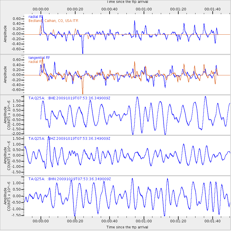
Q25A Bedland, Calhan, CO, USA - Earthquake Result Viewer
*The percent match for this event was below the threshold and hence no stack was calculated.
| Earthquake location: |
Samoa Islands Region |
| Earthquake latitude/longitude: |
-15.4/-173.0 |
| Earthquake time(UTC): |
2009/10/19 (292) 07:41:38 GMT |
| Earthquake Depth: |
10 km |
| Earthquake Magnitude: |
5.8 MW, 5.4 MS, 5.4 MB, 5.8 MW |
| Earthquake Catalog/Contributor: |
WHDF/NEIC |
|
| Network: |
TA USArray Transportable Network (new EarthScope stations) |
| Station: |
Q25A Bedland, Calhan, CO, USA |
| Lat/Lon: |
38.91 N/104.25 W |
| Elevation: |
2001 m |
|
| Distance: |
83.8 deg |
| Az: |
46.989 deg |
| Baz: |
244.677 deg |
| Ray Param: |
$rayparam |
*The percent match for this event was below the threshold and hence was not used in the summary stack. |
|
| Radial Match: |
61.067097 % |
| Radial Bump: |
400 |
| Transverse Match: |
47.35536 % |
| Transverse Bump: |
331 |
| SOD ConfigId: |
2622 |
| Insert Time: |
2010-03-06 03:07:40.824 +0000 |
| GWidth: |
2.5 |
| Max Bumps: |
400 |
| Tol: |
0.001 |
|
Signal To Noise
| Channel | StoN | STA | LTA |
| TA:Q25A: :BHZ:20091019T07:53:36.349009Z | 2.0092623 | 8.212328E-7 | 4.0872354E-7 |
| TA:Q25A: :BHN:20091019T07:53:36.349009Z | 0.28670716 | 2.1530379E-7 | 7.5095363E-7 |
| TA:Q25A: :BHE:20091019T07:53:36.349009Z | 1.292746 | 8.671238E-7 | 6.707612E-7 |
| Arrivals |
| Ps | |
| PpPs | |
| PsPs/PpSs | |


