You are here: Home > Network List > PB - Plate Boundary Observatory Borehole Seismic Network Stations List
> Station B088 skyoks088bcs2007, Anza, CA, USA > Earthquake Result Viewer
B088 skyoks088bcs2007, Anza, CA, USA - Earthquake Result Viewer
| Earthquake location: |
Kodiak Island Region, Alaska |
| Earthquake latitude/longitude: |
58.5/-153.7 |
| Earthquake time(UTC): |
2017/08/31 (243) 17:46:02 GMT |
| Earthquake Depth: |
62 km |
| Earthquake Magnitude: |
5.5 ml |
| Earthquake Catalog/Contributor: |
NEIC PDE/ak |
|
| Network: |
PB Plate Boundary Observatory Borehole Seismic Network |
| Station: |
B088 skyoks088bcs2007, Anza, CA, USA |
| Lat/Lon: |
33.37 N/116.62 W |
| Elevation: |
1404 m |
|
| Distance: |
35.2 deg |
| Az: |
119.088 deg |
| Baz: |
326.695 deg |
| Ray Param: |
0.07716841 |
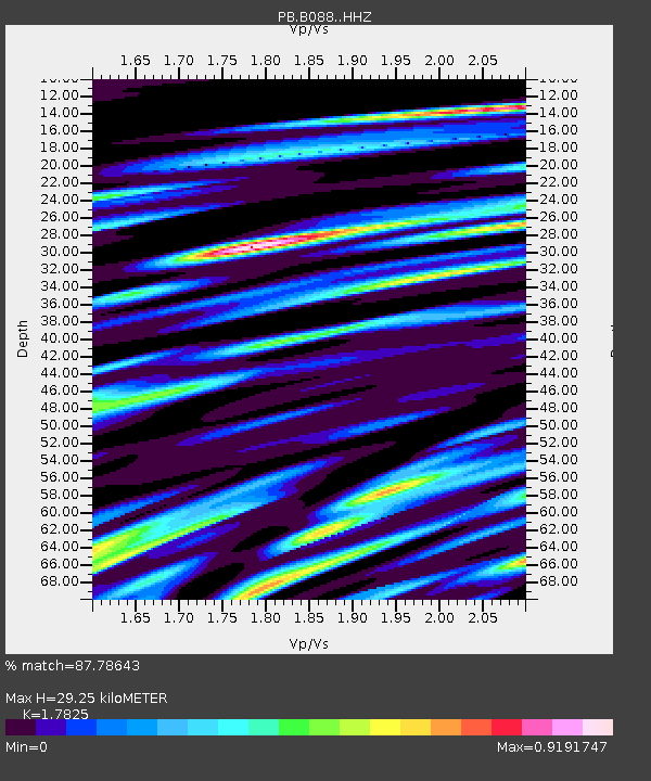
| Estimated Moho Depth: |
29.25 km |
| Estimated Crust Vp/Vs: |
1.78 |
| Assumed Crust Vp: |
6.264 km/s |
| Estimated Crust Vs: |
3.514 km/s |
| Estimated Crust Poisson's Ratio: |
0.27 |
|
| Radial Match: |
87.78643 % |
| Radial Bump: |
400 |
| Transverse Match: |
79.70425 % |
| Transverse Bump: |
400 |
| SOD ConfigId: |
13570011 |
| Insert Time: |
2019-04-28 16:00:43.065 +0000 |
| GWidth: |
2.5 |
| Max Bumps: |
400 |
| Tol: |
0.001 |
|

Signal To Noise
| Channel | StoN | STA | LTA |
| PB:B088: :HHZ:20170831T17:52:20.773994Z | 58.518192 | 1.9194165E-7 | 3.280034E-9 |
| PB:B088: :HH1:20170831T17:52:20.773994Z | 18.95305 | 4.389517E-8 | 2.315995E-9 |
| PB:B088: :HH2:20170831T17:52:20.773994Z | 35.90384 | 8.9172744E-8 | 2.4836546E-9 |
| Arrivals |
| Ps | 3.9 SECOND |
| PpPs | 12 SECOND |
| PsPs/PpSs | 16 SECOND |


