You are here: Home > Network List > TA - USArray Transportable Network (new EarthScope stations) Stations List
> Station K22A Casper, WY, USA > Earthquake Result Viewer
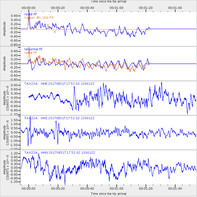
K22A Casper, WY, USA - Earthquake Result Viewer
*The percent match for this event was below the threshold and hence no stack was calculated.
| Earthquake location: |
Kodiak Island Region, Alaska |
| Earthquake latitude/longitude: |
58.5/-153.7 |
| Earthquake time(UTC): |
2017/08/31 (243) 17:46:02 GMT |
| Earthquake Depth: |
62 km |
| Earthquake Magnitude: |
5.5 ml |
| Earthquake Catalog/Contributor: |
NEIC PDE/ak |
|
| Network: |
TA USArray Transportable Network (new EarthScope stations) |
| Station: |
K22A Casper, WY, USA |
| Lat/Lon: |
42.65 N/106.52 W |
| Elevation: |
1686 m |
|
| Distance: |
33.1 deg |
| Az: |
97.59 deg |
| Baz: |
315.055 deg |
| Ray Param: |
$rayparam |
*The percent match for this event was below the threshold and hence was not used in the summary stack. |
|
| Radial Match: |
60.88309 % |
| Radial Bump: |
400 |
| Transverse Match: |
57.36084 % |
| Transverse Bump: |
400 |
| SOD ConfigId: |
13570011 |
| Insert Time: |
2019-04-28 16:01:45.279 +0000 |
| GWidth: |
2.5 |
| Max Bumps: |
400 |
| Tol: |
0.001 |
|
Signal To Noise
| Channel | StoN | STA | LTA |
| TA:K22A: :HHZ:20170831T17:52:02.130012Z | 2.2579746 | 7.255047E-7 | 3.2130774E-7 |
| TA:K22A: :HHN:20170831T17:52:02.130012Z | 2.8542705 | 7.8038084E-7 | 2.7340815E-7 |
| TA:K22A: :HHE:20170831T17:52:02.130012Z | 3.4714453 | 6.026375E-7 | 1.7359844E-7 |
| Arrivals |
| Ps | |
| PpPs | |
| PsPs/PpSs | |


