You are here: Home > Network List > TA - USArray Transportable Network (new EarthScope stations) Stations List
> Station MSTX Muleshoe, TX, USA > Earthquake Result Viewer
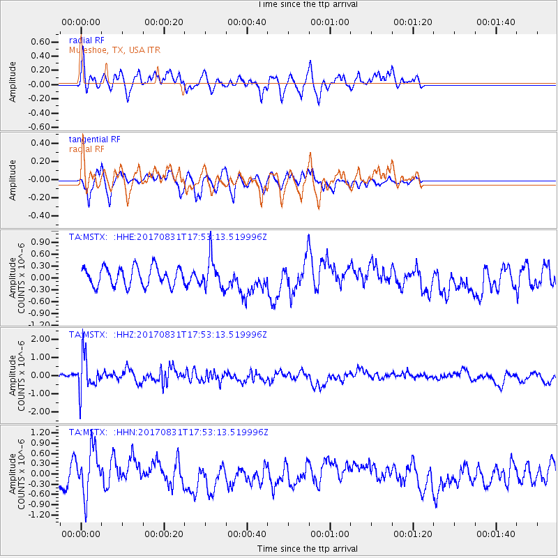
MSTX Muleshoe, TX, USA - Earthquake Result Viewer
*The percent match for this event was below the threshold and hence no stack was calculated.
| Earthquake location: |
Kodiak Island Region, Alaska |
| Earthquake latitude/longitude: |
58.5/-153.7 |
| Earthquake time(UTC): |
2017/08/31 (243) 17:46:02 GMT |
| Earthquake Depth: |
62 km |
| Earthquake Magnitude: |
5.5 ml |
| Earthquake Catalog/Contributor: |
NEIC PDE/ak |
|
| Network: |
TA USArray Transportable Network (new EarthScope stations) |
| Station: |
MSTX Muleshoe, TX, USA |
| Lat/Lon: |
33.97 N/102.77 W |
| Elevation: |
1167 m |
|
| Distance: |
41.5 deg |
| Az: |
103.402 deg |
| Baz: |
322.017 deg |
| Ray Param: |
$rayparam |
*The percent match for this event was below the threshold and hence was not used in the summary stack. |
|
| Radial Match: |
57.176655 % |
| Radial Bump: |
400 |
| Transverse Match: |
53.915188 % |
| Transverse Bump: |
284 |
| SOD ConfigId: |
13570011 |
| Insert Time: |
2019-04-28 16:01:49.102 +0000 |
| GWidth: |
2.5 |
| Max Bumps: |
400 |
| Tol: |
0.001 |
|
Signal To Noise
| Channel | StoN | STA | LTA |
| TA:MSTX: :HHZ:20170831T17:53:13.519996Z | 5.9981875 | 9.83915E-7 | 1.6403538E-7 |
| TA:MSTX: :HHN:20170831T17:53:13.519996Z | 2.351823 | 7.0129715E-7 | 2.9819302E-7 |
| TA:MSTX: :HHE:20170831T17:53:13.519996Z | 1.6675417 | 3.930996E-7 | 2.3573598E-7 |
| Arrivals |
| Ps | |
| PpPs | |
| PsPs/PpSs | |


