You are here: Home > Network List > TA - USArray Transportable Network (new EarthScope stations) Stations List
> Station O20A White River City, CO, USA > Earthquake Result Viewer
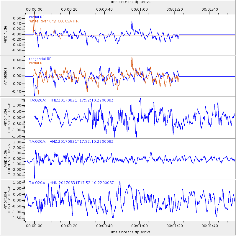
O20A White River City, CO, USA - Earthquake Result Viewer
*The percent match for this event was below the threshold and hence no stack was calculated.
| Earthquake location: |
Kodiak Island Region, Alaska |
| Earthquake latitude/longitude: |
58.5/-153.7 |
| Earthquake time(UTC): |
2017/08/31 (243) 17:46:02 GMT |
| Earthquake Depth: |
62 km |
| Earthquake Magnitude: |
5.5 ml |
| Earthquake Catalog/Contributor: |
NEIC PDE/ak |
|
| Network: |
TA USArray Transportable Network (new EarthScope stations) |
| Station: |
O20A White River City, CO, USA |
| Lat/Lon: |
40.13 N/108.24 W |
| Elevation: |
1915 m |
|
| Distance: |
34.0 deg |
| Az: |
102.421 deg |
| Baz: |
317.952 deg |
| Ray Param: |
$rayparam |
*The percent match for this event was below the threshold and hence was not used in the summary stack. |
|
| Radial Match: |
68.565636 % |
| Radial Bump: |
400 |
| Transverse Match: |
56.228134 % |
| Transverse Bump: |
400 |
| SOD ConfigId: |
13570011 |
| Insert Time: |
2019-04-28 16:01:49.957 +0000 |
| GWidth: |
2.5 |
| Max Bumps: |
400 |
| Tol: |
0.001 |
|
Signal To Noise
| Channel | StoN | STA | LTA |
| TA:O20A: :HHZ:20170831T17:52:10.220008Z | 2.6037786 | 9.941082E-7 | 3.8179442E-7 |
| TA:O20A: :HHN:20170831T17:52:10.220008Z | 1.312366 | 4.4825032E-7 | 3.4155892E-7 |
| TA:O20A: :HHE:20170831T17:52:10.220008Z | 1.1768773 | 5.072121E-7 | 4.3098132E-7 |
| Arrivals |
| Ps | |
| PpPs | |
| PsPs/PpSs | |


