You are here: Home > Network List > G - GEOSCOPE Stations List
> Station NOUC Port Laguerre, New Caledonia > Earthquake Result Viewer
NOUC Port Laguerre, New Caledonia - Earthquake Result Viewer
| Earthquake location: |
Balleny Islands Region |
| Earthquake latitude/longitude: |
-63.3/169.2 |
| Earthquake time(UTC): |
2016/01/31 (031) 17:39:00 GMT |
| Earthquake Depth: |
10 km |
| Earthquake Magnitude: |
6.0 MWB |
| Earthquake Catalog/Contributor: |
NEIC PDE/NEIC COMCAT |
|
| Network: |
G GEOSCOPE |
| Station: |
NOUC Port Laguerre, New Caledonia |
| Lat/Lon: |
22.10 S/166.30 E |
| Elevation: |
112 m |
|
| Distance: |
41.2 deg |
| Az: |
355.988 deg |
| Baz: |
178.046 deg |
| Ray Param: |
0.07393555 |
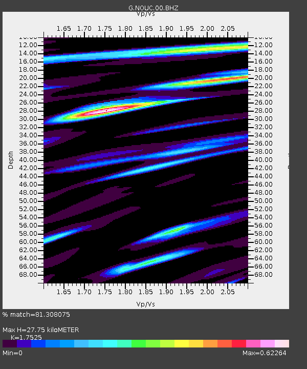
| Estimated Moho Depth: |
27.75 km |
| Estimated Crust Vp/Vs: |
1.75 |
| Assumed Crust Vp: |
5.14 km/s |
| Estimated Crust Vs: |
2.933 km/s |
| Estimated Crust Poisson's Ratio: |
0.26 |
|
| Radial Match: |
81.308075 % |
| Radial Bump: |
320 |
| Transverse Match: |
71.51703 % |
| Transverse Bump: |
400 |
| SOD ConfigId: |
1427151 |
| Insert Time: |
2016-02-14 18:08:13.940 +0000 |
| GWidth: |
2.5 |
| Max Bumps: |
400 |
| Tol: |
0.001 |
|

Signal To Noise
| Channel | StoN | STA | LTA |
| G:NOUC:00:BHZ:20160131T17:46:14.248994Z | 4.389834 | 6.726019E-7 | 1.5321808E-7 |
| G:NOUC:00:BHN:20160131T17:46:14.248994Z | 2.2164814 | 4.8766134E-7 | 2.2001599E-7 |
| G:NOUC:00:BHE:20160131T17:46:14.248994Z | 1.0945946 | 1.1958778E-7 | 1.0925303E-7 |
| Arrivals |
| Ps | 4.2 SECOND |
| PpPs | 14 SECOND |
| PsPs/PpSs | 18 SECOND |


