You are here: Home > Network List > TA - USArray Transportable Network (new EarthScope stations) Stations List
> Station I06A Prineville, OR, USA > Earthquake Result Viewer
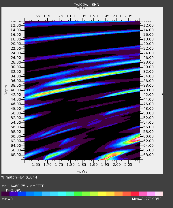
I06A Prineville, OR, USA - Earthquake Result Viewer
| Earthquake location: |
Taiwan Region |
| Earthquake latitude/longitude: |
24.3/122.2 |
| Earthquake time(UTC): |
2007/09/06 (249) 17:51:26 GMT |
| Earthquake Depth: |
53 km |
| Earthquake Magnitude: |
6.1 MB, 6.2 MW, 6.1 ME |
| Earthquake Catalog/Contributor: |
WHDF/NEIC |
|
| Network: |
TA USArray Transportable Network (new EarthScope stations) |
| Station: |
I06A Prineville, OR, USA |
| Lat/Lon: |
43.94 N/120.21 W |
| Elevation: |
1297 m |
|
| Distance: |
91.2 deg |
| Az: |
39.827 deg |
| Baz: |
306.025 deg |
| Ray Param: |
0.041608136 |
| Estimated Moho Depth: |
60.75 km |
| Estimated Crust Vp/Vs: |
2.10 |
| Assumed Crust Vp: |
6.597 km/s |
| Estimated Crust Vs: |
3.149 km/s |
| Estimated Crust Poisson's Ratio: |
0.35 |
|
| Radial Match: |
84.61044 % |
| Radial Bump: |
400 |
| Transverse Match: |
78.62395 % |
| Transverse Bump: |
400 |
| SOD ConfigId: |
2564 |
| Insert Time: |
2010-03-06 03:09:17.099 +0000 |
| GWidth: |
2.5 |
| Max Bumps: |
400 |
| Tol: |
0.001 |
|

Signal To Noise
| Channel | StoN | STA | LTA |
| TA:I06A: :BHN:20070906T18:03:54.45001Z | 2.9221923 | 4.097729E-7 | 1.402279E-7 |
| TA:I06A: :BHE:20070906T18:03:54.45001Z | 2.3009665 | 3.23887E-7 | 1.4076129E-7 |
| TA:I06A: :BHZ:20070906T18:03:54.45001Z | 13.9100485 | 1.2259474E-6 | 8.813394E-8 |
| Arrivals |
| Ps | 10 SECOND |
| PpPs | 28 SECOND |
| PsPs/PpSs | 38 SECOND |


