You are here: Home > Network List > TA - USArray Transportable Network (new EarthScope stations) Stations List
> Station I06A Prineville, OR, USA > Earthquake Result Viewer
I06A Prineville, OR, USA - Earthquake Result Viewer
| Earthquake location: |
Tonga Islands |
| Earthquake latitude/longitude: |
-17.5/-174.3 |
| Earthquake time(UTC): |
2007/08/26 (238) 12:37:31 GMT |
| Earthquake Depth: |
127 km |
| Earthquake Magnitude: |
5.9 MB, 6.1 MW |
| Earthquake Catalog/Contributor: |
WHDF/NEIC |
|
| Network: |
TA USArray Transportable Network (new EarthScope stations) |
| Station: |
I06A Prineville, OR, USA |
| Lat/Lon: |
43.94 N/120.21 W |
| Elevation: |
1297 m |
|
| Distance: |
78.6 deg |
| Az: |
36.664 deg |
| Baz: |
232.096 deg |
| Ray Param: |
0.04924114 |
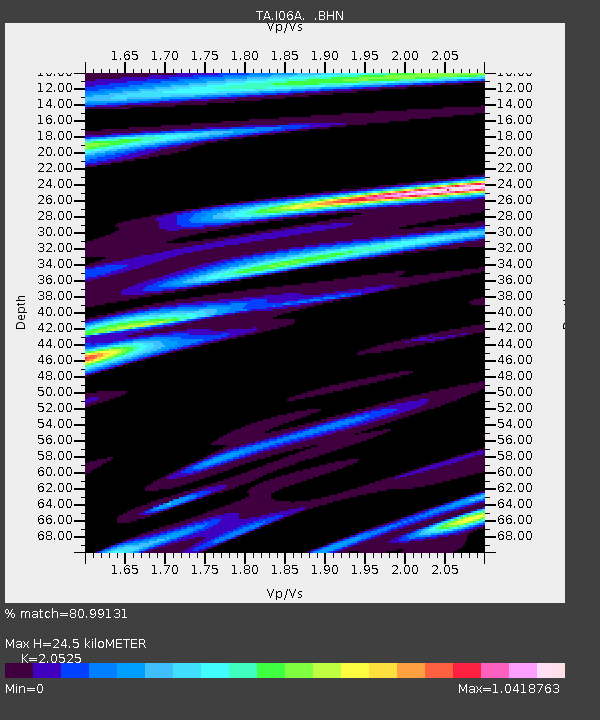
| Estimated Moho Depth: |
24.5 km |
| Estimated Crust Vp/Vs: |
2.05 |
| Assumed Crust Vp: |
6.597 km/s |
| Estimated Crust Vs: |
3.214 km/s |
| Estimated Crust Poisson's Ratio: |
0.34 |
|
| Radial Match: |
80.99131 % |
| Radial Bump: |
400 |
| Transverse Match: |
81.94337 % |
| Transverse Bump: |
400 |
| SOD ConfigId: |
2564 |
| Insert Time: |
2010-03-06 03:09:23.810 +0000 |
| GWidth: |
2.5 |
| Max Bumps: |
400 |
| Tol: |
0.001 |
|
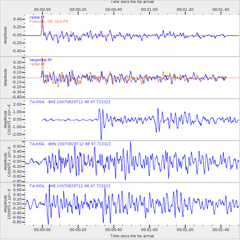
Signal To Noise
| Channel | StoN | STA | LTA |
| TA:I06A: :BHN:20070826T12:48:47.72302Z | 1.8343754 | 1.5394744E-7 | 8.392363E-8 |
| TA:I06A: :BHE:20070826T12:48:47.72302Z | 3.927924 | 3.5198377E-7 | 8.961064E-8 |
| TA:I06A: :BHZ:20070826T12:48:47.72302Z | 15.186086 | 1.0015931E-6 | 6.595466E-8 |
| Arrivals |
| Ps | 4.0 SECOND |
| PpPs | 11 SECOND |
| PsPs/PpSs | 15 SECOND |


