You are here: Home > Network List > TA - USArray Transportable Network (new EarthScope stations) Stations List
> Station O18K Koktuh Hills, AK, USA > Earthquake Result Viewer
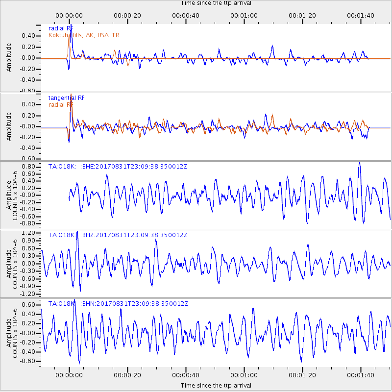
O18K Koktuh Hills, AK, USA - Earthquake Result Viewer
*The percent match for this event was below the threshold and hence no stack was calculated.
| Earthquake location: |
Southern Molucca Sea |
| Earthquake latitude/longitude: |
-0.2/125.2 |
| Earthquake time(UTC): |
2017/08/31 (243) 22:57:39 GMT |
| Earthquake Depth: |
47 km |
| Earthquake Magnitude: |
5.4 Mww |
| Earthquake Catalog/Contributor: |
NEIC PDE/us |
|
| Network: |
TA USArray Transportable Network (new EarthScope stations) |
| Station: |
O18K Koktuh Hills, AK, USA |
| Lat/Lon: |
59.85 N/155.21 W |
| Elevation: |
544 m |
|
| Distance: |
85.0 deg |
| Az: |
29.889 deg |
| Baz: |
260.858 deg |
| Ray Param: |
$rayparam |
*The percent match for this event was below the threshold and hence was not used in the summary stack. |
|
| Radial Match: |
63.260006 % |
| Radial Bump: |
400 |
| Transverse Match: |
62.600445 % |
| Transverse Bump: |
400 |
| SOD ConfigId: |
13570011 |
| Insert Time: |
2019-04-28 16:06:32.011 +0000 |
| GWidth: |
2.5 |
| Max Bumps: |
400 |
| Tol: |
0.001 |
|
Signal To Noise
| Channel | StoN | STA | LTA |
| TA:O18K: :BHZ:20170831T23:09:38.350012Z | 2.907864 | 6.2743834E-7 | 2.1577291E-7 |
| TA:O18K: :BHN:20170831T23:09:38.350012Z | 1.3753909 | 3.9714905E-7 | 2.887536E-7 |
| TA:O18K: :BHE:20170831T23:09:38.350012Z | 1.2205249 | 2.9059805E-7 | 2.380927E-7 |
| Arrivals |
| Ps | |
| PpPs | |
| PsPs/PpSs | |


