You are here: Home > Network List > TA - USArray Transportable Network (new EarthScope stations) Stations List
> Station I06A Prineville, OR, USA > Earthquake Result Viewer
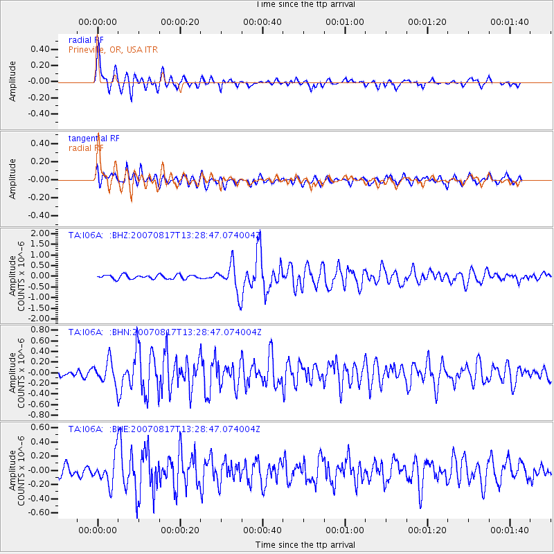
I06A Prineville, OR, USA - Earthquake Result Viewer

| Earthquake location: |
Near Coast Of Peru |
| Earthquake latitude/longitude: |
-13.6/-76.6 |
| Earthquake time(UTC): |
2007/08/17 (229) 13:18:13 GMT |
| Earthquake Depth: |
48 km |
| Earthquake Magnitude: |
5.6 MB, 5.6 MS, 5.9 MW |
| Earthquake Catalog/Contributor: |
WHDF/NEIC |
|
| Network: |
TA USArray Transportable Network (new EarthScope stations) |
| Station: |
I06A Prineville, OR, USA |
| Lat/Lon: |
43.94 N/120.21 W |
| Elevation: |
1297 m |
|
| Distance: |
69.7 deg |
| Az: |
327.912 deg |
| Baz: |
134.353 deg |
| Ray Param: |
0.05537453 |
| Estimated Moho Depth: |
10.5 km |
| Estimated Crust Vp/Vs: |
1.92 |
| Assumed Crust Vp: |
6.597 km/s |
| Estimated Crust Vs: |
3.436 km/s |
| Estimated Crust Poisson's Ratio: |
0.31 |
|
| Radial Match: |
82.34156 % |
| Radial Bump: |
400 |
| Transverse Match: |
81.553825 % |
| Transverse Bump: |
400 |
| SOD ConfigId: |
2564 |
| Insert Time: |
2010-03-06 03:09:27.366 +0000 |
| GWidth: |
2.5 |
| Max Bumps: |
400 |
| Tol: |
0.001 |
|
Signal To Noise
| Channel | StoN | STA | LTA |
| TA:I06A: :BHN:20070817T13:28:47.074004Z | 2.4228888 | 2.206591E-7 | 9.107273E-8 |
| TA:I06A: :BHE:20070817T13:28:47.074004Z | 3.206695 | 2.0504214E-7 | 6.394189E-8 |
| TA:I06A: :BHZ:20070817T13:28:47.074004Z | 7.524368 | 7.0330213E-7 | 9.346993E-8 |
| Arrivals |
| Ps | 1.5 SECOND |
| PpPs | 4.5 SECOND |
| PsPs/PpSs | 6.0 SECOND |


