You are here: Home > Network List > TA - USArray Transportable Network (new EarthScope stations) Stations List
> Station I06A Prineville, OR, USA > Earthquake Result Viewer
I06A Prineville, OR, USA - Earthquake Result Viewer
| Earthquake location: |
Andreanof Islands, Aleutian Is. |
| Earthquake latitude/longitude: |
50.2/-177.6 |
| Earthquake time(UTC): |
2007/08/16 (228) 04:03:03 GMT |
| Earthquake Depth: |
15 km |
| Earthquake Magnitude: |
5.8 MB |
| Earthquake Catalog/Contributor: |
WHDF/NEIC |
|
| Network: |
TA USArray Transportable Network (new EarthScope stations) |
| Station: |
I06A Prineville, OR, USA |
| Lat/Lon: |
43.94 N/120.21 W |
| Elevation: |
1297 m |
|
| Distance: |
38.7 deg |
| Az: |
76.565 deg |
| Baz: |
300.17 deg |
| Ray Param: |
0.07539361 |
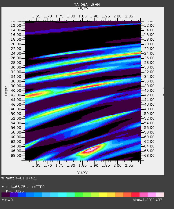
| Estimated Moho Depth: |
65.25 km |
| Estimated Crust Vp/Vs: |
1.88 |
| Assumed Crust Vp: |
6.597 km/s |
| Estimated Crust Vs: |
3.505 km/s |
| Estimated Crust Poisson's Ratio: |
0.30 |
|
| Radial Match: |
81.07421 % |
| Radial Bump: |
400 |
| Transverse Match: |
73.03568 % |
| Transverse Bump: |
392 |
| SOD ConfigId: |
2564 |
| Insert Time: |
2010-03-06 03:09:30.160 +0000 |
| GWidth: |
2.5 |
| Max Bumps: |
400 |
| Tol: |
0.001 |
|

Signal To Noise
| Channel | StoN | STA | LTA |
| TA:I06A: :BHN:20070816T04:09:56.000Z | 3.1502433 | 5.5794777E-7 | 1.7711258E-7 |
| TA:I06A: :BHE:20070816T04:09:56.000Z | 2.7795808 | 5.703985E-7 | 2.0521028E-7 |
| TA:I06A: :BHZ:20070816T04:09:56.000Z | 3.5053694 | 8.837792E-7 | 2.5212157E-7 |
| Arrivals |
| Ps | 9.4 SECOND |
| PpPs | 27 SECOND |
| PsPs/PpSs | 36 SECOND |


