You are here: Home > Network List > TA - USArray Transportable Network (new EarthScope stations) Stations List
> Station I06A Prineville, OR, USA > Earthquake Result Viewer
I06A Prineville, OR, USA - Earthquake Result Viewer
| Earthquake location: |
Vanuatu Islands |
| Earthquake latitude/longitude: |
-15.6/167.7 |
| Earthquake time(UTC): |
2007/08/01 (213) 17:08:51 GMT |
| Earthquake Depth: |
120 km |
| Earthquake Magnitude: |
6.2 MB, 7.2 MW, 7.2 MW |
| Earthquake Catalog/Contributor: |
WHDF/NEIC |
|
| Network: |
TA USArray Transportable Network (new EarthScope stations) |
| Station: |
I06A Prineville, OR, USA |
| Lat/Lon: |
43.94 N/120.21 W |
| Elevation: |
1297 m |
|
| Distance: |
88.3 deg |
| Az: |
43.449 deg |
| Baz: |
246.555 deg |
| Ray Param: |
0.042406276 |
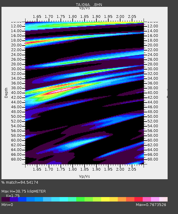
| Estimated Moho Depth: |
38.75 km |
| Estimated Crust Vp/Vs: |
1.75 |
| Assumed Crust Vp: |
6.597 km/s |
| Estimated Crust Vs: |
3.77 km/s |
| Estimated Crust Poisson's Ratio: |
0.26 |
|
| Radial Match: |
94.54174 % |
| Radial Bump: |
400 |
| Transverse Match: |
91.805954 % |
| Transverse Bump: |
400 |
| SOD ConfigId: |
2564 |
| Insert Time: |
2010-03-06 03:09:32.817 +0000 |
| GWidth: |
2.5 |
| Max Bumps: |
400 |
| Tol: |
0.001 |
|

Signal To Noise
| Channel | StoN | STA | LTA |
| TA:I06A: :BHN:20070801T17:20:58.373022Z | 2.0300798 | 2.398218E-7 | 1.1813417E-7 |
| TA:I06A: :BHE:20070801T17:20:58.373022Z | 2.5711741 | 2.6160708E-7 | 1.0174616E-7 |
| TA:I06A: :BHZ:20070801T17:20:58.373022Z | 5.7832522 | 6.176999E-7 | 1.068084E-7 |
| Arrivals |
| Ps | 4.5 SECOND |
| PpPs | 16 SECOND |
| PsPs/PpSs | 20 SECOND |


