You are here: Home > Network List > TA - USArray Transportable Network (new EarthScope stations) Stations List
> Station I06A Prineville, OR, USA > Earthquake Result Viewer
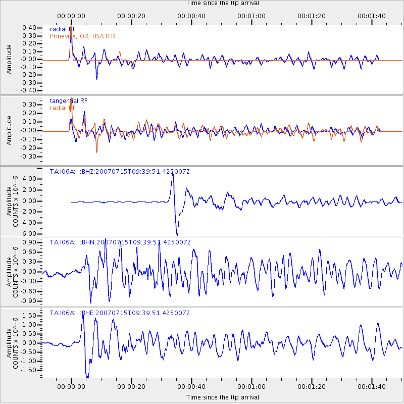
I06A Prineville, OR, USA - Earthquake Result Viewer

| Earthquake location: |
Vanuatu Islands |
| Earthquake latitude/longitude: |
-15.4/168.6 |
| Earthquake time(UTC): |
2007/07/15 (196) 09:27:34 GMT |
| Earthquake Depth: |
8.0 km |
| Earthquake Magnitude: |
6.0 MB, 5.8 MS, 6.1 MW, 6.0 MW |
| Earthquake Catalog/Contributor: |
WHDF/NEIC |
|
| Network: |
TA USArray Transportable Network (new EarthScope stations) |
| Station: |
I06A Prineville, OR, USA |
| Lat/Lon: |
43.94 N/120.21 W |
| Elevation: |
1297 m |
|
| Distance: |
87.6 deg |
| Az: |
43.188 deg |
| Baz: |
246.056 deg |
| Ray Param: |
0.043232884 |
| Estimated Moho Depth: |
37.0 km |
| Estimated Crust Vp/Vs: |
1.73 |
| Assumed Crust Vp: |
6.597 km/s |
| Estimated Crust Vs: |
3.819 km/s |
| Estimated Crust Poisson's Ratio: |
0.25 |
|
| Radial Match: |
93.9086 % |
| Radial Bump: |
302 |
| Transverse Match: |
85.65751 % |
| Transverse Bump: |
400 |
| SOD ConfigId: |
2564 |
| Insert Time: |
2010-03-06 03:09:45.811 +0000 |
| GWidth: |
2.5 |
| Max Bumps: |
400 |
| Tol: |
0.001 |
|
Signal To Noise
| Channel | StoN | STA | LTA |
| TA:I06A: :BHN:20070715T09:39:51.425007Z | 1.1874049 | 1.047997E-7 | 8.8259455E-8 |
| TA:I06A: :BHE:20070715T09:39:51.425007Z | 5.6858597 | 6.280419E-7 | 1.1045681E-7 |
| TA:I06A: :BHZ:20070715T09:39:51.425007Z | 42.19001 | 2.0341763E-6 | 4.8214645E-8 |
| Arrivals |
| Ps | 4.2 SECOND |
| PpPs | 15 SECOND |
| PsPs/PpSs | 19 SECOND |


