You are here: Home > Network List > G - GEOSCOPE Stations List
> Station INU Inuyama, Japan > Earthquake Result Viewer
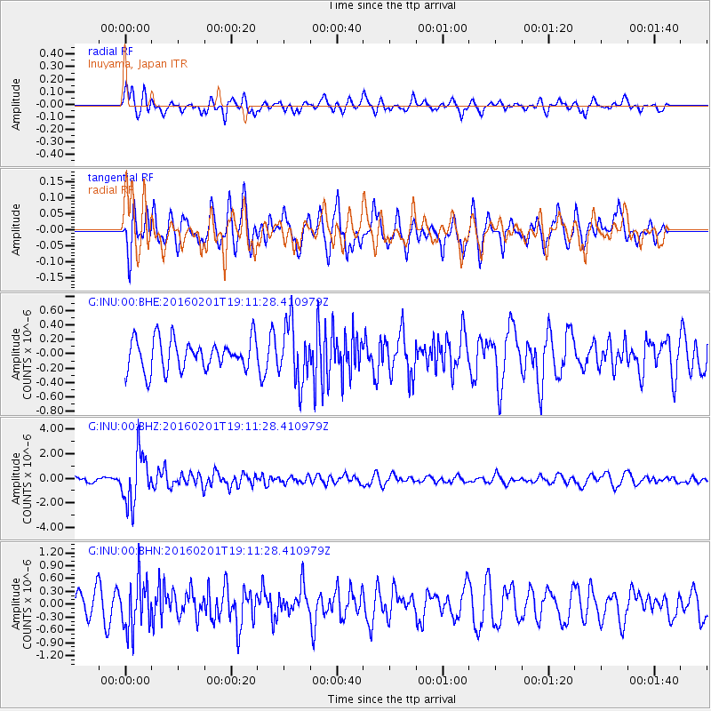
INU Inuyama, Japan - Earthquake Result Viewer
*The percent match for this event was below the threshold and hence no stack was calculated.
| Earthquake location: |
Kermadec Islands Region |
| Earthquake latitude/longitude: |
-31.0/-179.9 |
| Earthquake time(UTC): |
2016/02/01 (032) 19:00:44 GMT |
| Earthquake Depth: |
370 km |
| Earthquake Magnitude: |
5.8 MB |
| Earthquake Catalog/Contributor: |
NEIC PDE/NEIC COMCAT |
|
| Network: |
G GEOSCOPE |
| Station: |
INU Inuyama, Japan |
| Lat/Lon: |
35.35 N/137.03 E |
| Elevation: |
132 m |
|
| Distance: |
77.4 deg |
| Az: |
325.134 deg |
| Baz: |
143.091 deg |
| Ray Param: |
$rayparam |
*The percent match for this event was below the threshold and hence was not used in the summary stack. |
|
| Radial Match: |
59.05193 % |
| Radial Bump: |
391 |
| Transverse Match: |
61.23422 % |
| Transverse Bump: |
400 |
| SOD ConfigId: |
1427151 |
| Insert Time: |
2016-02-15 19:24:56.962 +0000 |
| GWidth: |
2.5 |
| Max Bumps: |
400 |
| Tol: |
0.001 |
|
Signal To Noise
| Channel | StoN | STA | LTA |
| G:INU:00:BHZ:20160201T19:11:28.410979Z | 8.391642 | 2.0705272E-6 | 2.4673685E-7 |
| G:INU:00:BHN:20160201T19:11:28.410979Z | 2.4668367 | 5.8757917E-7 | 2.3819136E-7 |
| G:INU:00:BHE:20160201T19:11:28.410979Z | 1.9204762 | 4.1134786E-7 | 2.1419055E-7 |
| Arrivals |
| Ps | |
| PpPs | |
| PsPs/PpSs | |


