You are here: Home > Network List > CI - Caltech Regional Seismic Network Stations List
> Station SWS Sam W. Stewart, Westmorland, CA, USA > Earthquake Result Viewer
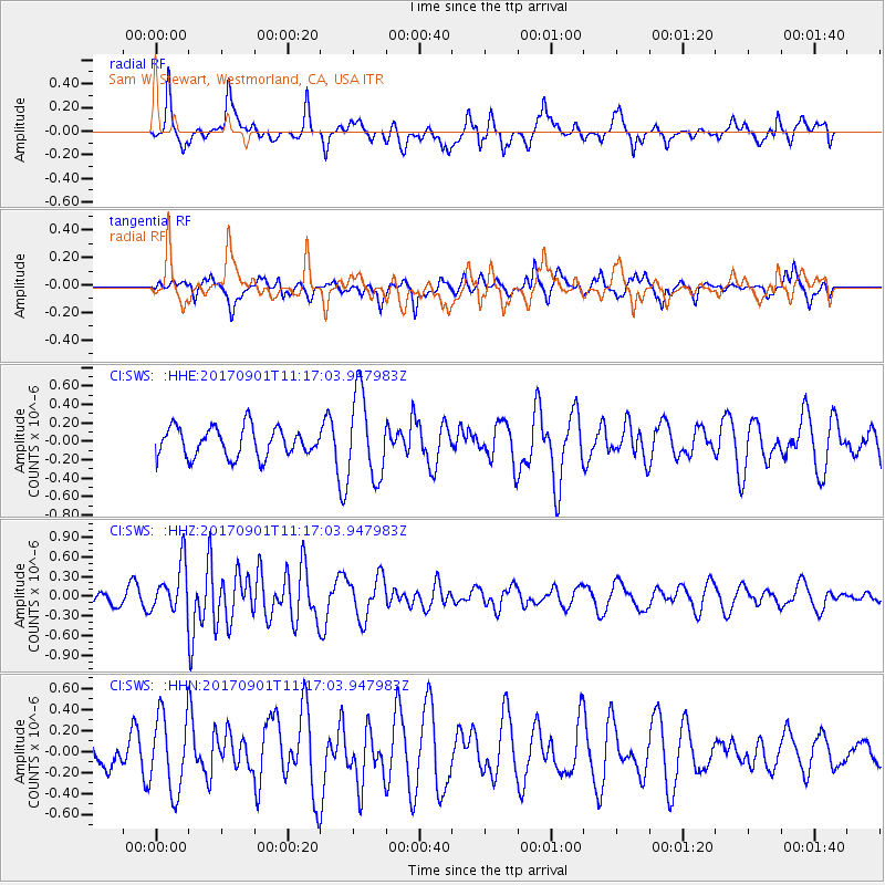
SWS Sam W. Stewart, Westmorland, CA, USA - Earthquake Result Viewer
*The percent match for this event was below the threshold and hence no stack was calculated.
| Earthquake location: |
Reykjanes Ridge |
| Earthquake latitude/longitude: |
57.0/-34.0 |
| Earthquake time(UTC): |
2017/09/01 (244) 11:07:37 GMT |
| Earthquake Depth: |
10 km |
| Earthquake Magnitude: |
5.7 Mww |
| Earthquake Catalog/Contributor: |
NEIC PDE/us |
|
| Network: |
CI Caltech Regional Seismic Network |
| Station: |
SWS Sam W. Stewart, Westmorland, CA, USA |
| Lat/Lon: |
32.94 N/115.80 W |
| Elevation: |
140 m |
|
| Distance: |
58.7 deg |
| Az: |
283.184 deg |
| Baz: |
39.255 deg |
| Ray Param: |
$rayparam |
*The percent match for this event was below the threshold and hence was not used in the summary stack. |
|
| Radial Match: |
53.88829 % |
| Radial Bump: |
398 |
| Transverse Match: |
48.733753 % |
| Transverse Bump: |
400 |
| SOD ConfigId: |
13570011 |
| Insert Time: |
2019-04-28 16:10:02.117 +0000 |
| GWidth: |
2.5 |
| Max Bumps: |
400 |
| Tol: |
0.001 |
|
Signal To Noise
| Channel | StoN | STA | LTA |
| CI:SWS: :HHZ:20170901T11:17:03.947983Z | 2.8887873 | 3.6670886E-7 | 1.2694215E-7 |
| CI:SWS: :HHN:20170901T11:17:03.947983Z | 2.9533207 | 3.642281E-7 | 1.2332832E-7 |
| CI:SWS: :HHE:20170901T11:17:03.947983Z | 2.909204 | 4.608205E-7 | 1.5840088E-7 |
| Arrivals |
| Ps | |
| PpPs | |
| PsPs/PpSs | |


