You are here: Home > Network List > TA - USArray Transportable Network (new EarthScope stations) Stations List
> Station I06A Prineville, OR, USA > Earthquake Result Viewer
I06A Prineville, OR, USA - Earthquake Result Viewer
| Earthquake location: |
Guerrero, Mexico |
| Earthquake latitude/longitude: |
18.6/-101.1 |
| Earthquake time(UTC): |
2006/08/11 (223) 14:30:40 GMT |
| Earthquake Depth: |
60 km |
| Earthquake Magnitude: |
6.0 MB, 6.1 MW, 6.0 MW |
| Earthquake Catalog/Contributor: |
WHDF/NEIC |
|
| Network: |
TA USArray Transportable Network (new EarthScope stations) |
| Station: |
I06A Prineville, OR, USA |
| Lat/Lon: |
43.94 N/120.21 W |
| Elevation: |
1297 m |
|
| Distance: |
30.0 deg |
| Az: |
331.701 deg |
| Baz: |
141.496 deg |
| Ray Param: |
0.07936589 |
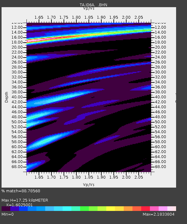
| Estimated Moho Depth: |
17.25 km |
| Estimated Crust Vp/Vs: |
1.60 |
| Assumed Crust Vp: |
6.597 km/s |
| Estimated Crust Vs: |
4.117 km/s |
| Estimated Crust Poisson's Ratio: |
0.18 |
|
| Radial Match: |
88.78568 % |
| Radial Bump: |
344 |
| Transverse Match: |
55.72179 % |
| Transverse Bump: |
400 |
| SOD ConfigId: |
2665 |
| Insert Time: |
2010-03-06 03:10:29.423 +0000 |
| GWidth: |
2.5 |
| Max Bumps: |
400 |
| Tol: |
0.001 |
|
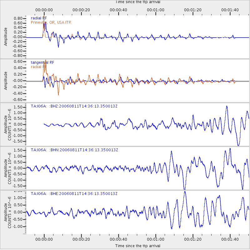
Signal To Noise
| Channel | StoN | STA | LTA |
| TA:I06A: :BHN:20060811T14:36:13.350013Z | 1.9821087 | 1.7909593E-7 | 9.035626E-8 |
| TA:I06A: :BHE:20060811T14:36:13.350013Z | 1.3517408 | 1.6314323E-7 | 1.206912E-7 |
| TA:I06A: :BHZ:20060811T14:36:13.350013Z | 3.1612577 | 3.1075362E-7 | 9.8300625E-8 |
| Arrivals |
| Ps | 1.7 SECOND |
| PpPs | 6.2 SECOND |
| PsPs/PpSs | 7.9 SECOND |


