You are here: Home > Network List > IU - Global Seismograph Network (GSN - IRIS/USGS) Stations List
> Station CTAO Charters Towers, Australia > Earthquake Result Viewer
CTAO Charters Towers, Australia - Earthquake Result Viewer
| Earthquake location: |
Kermadec Islands Region |
| Earthquake latitude/longitude: |
-31.0/-179.9 |
| Earthquake time(UTC): |
2016/02/01 (032) 19:00:44 GMT |
| Earthquake Depth: |
370 km |
| Earthquake Magnitude: |
5.8 MB |
| Earthquake Catalog/Contributor: |
NEIC PDE/NEIC COMCAT |
|
| Network: |
IU Global Seismograph Network (GSN - IRIS/USGS) |
| Station: |
CTAO Charters Towers, Australia |
| Lat/Lon: |
20.09 S/146.25 E |
| Elevation: |
357 m |
|
| Distance: |
32.3 deg |
| Az: |
281.551 deg |
| Baz: |
116.47 deg |
| Ray Param: |
0.077351525 |
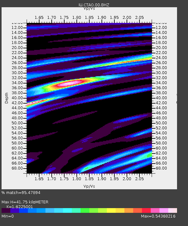
| Estimated Moho Depth: |
41.75 km |
| Estimated Crust Vp/Vs: |
1.62 |
| Assumed Crust Vp: |
6.522 km/s |
| Estimated Crust Vs: |
4.019 km/s |
| Estimated Crust Poisson's Ratio: |
0.19 |
|
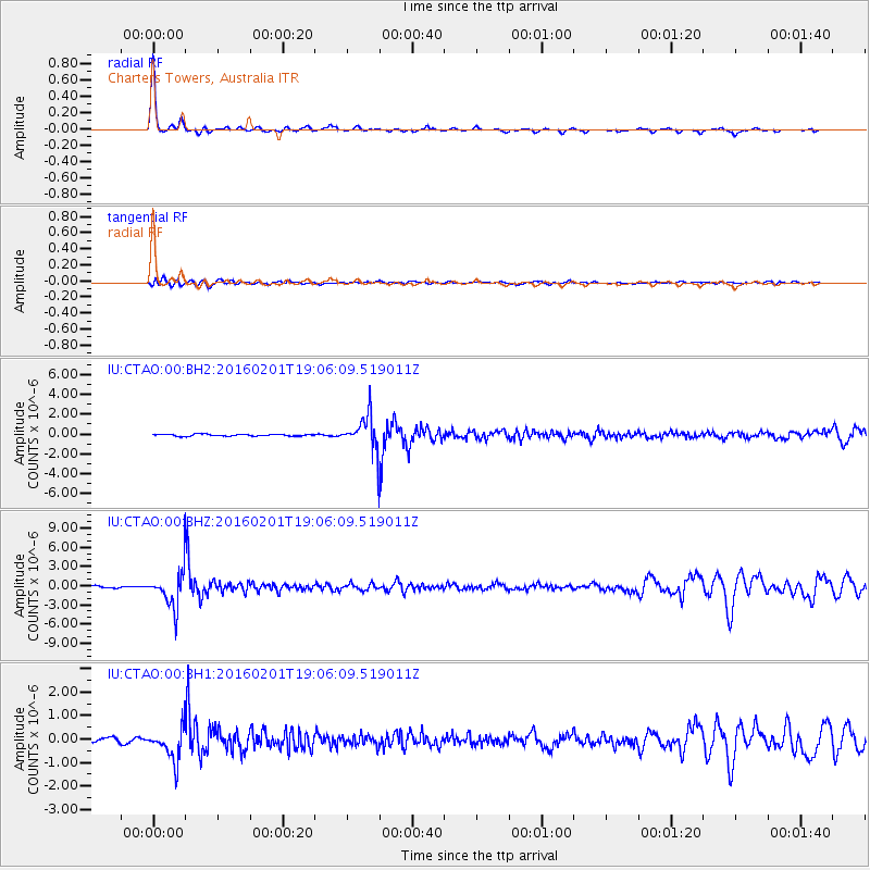
| Radial Match: |
95.47894 % |
| Radial Bump: |
208 |
| Transverse Match: |
71.754 % |
| Transverse Bump: |
400 |
| SOD ConfigId: |
1427151 |
| Insert Time: |
2016-02-15 19:26:16.311 +0000 |
| GWidth: |
2.5 |
| Max Bumps: |
400 |
| Tol: |
0.001 |
|
Signal To Noise
| Channel | StoN | STA | LTA |
| IU:CTAO:00:BHZ:20160201T19:06:09.519011Z | 17.338009 | 2.8243414E-6 | 1.6289884E-7 |
| IU:CTAO:00:BH1:20160201T19:06:09.519011Z | 7.7163973 | 7.026676E-7 | 9.106162E-8 |
| IU:CTAO:00:BH2:20160201T19:06:09.519011Z | 17.505161 | 1.7211671E-6 | 9.832341E-8 |
| Arrivals |
| Ps | 4.3 SECOND |
| PpPs | 15 SECOND |
| PsPs/PpSs | 20 SECOND |


