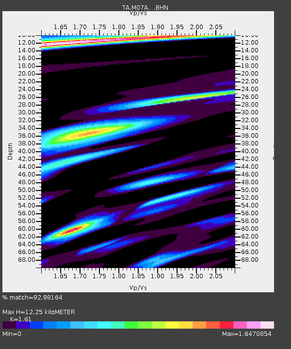
M07A Soldier Meadows, NV, USA - Earthquake Result Viewer
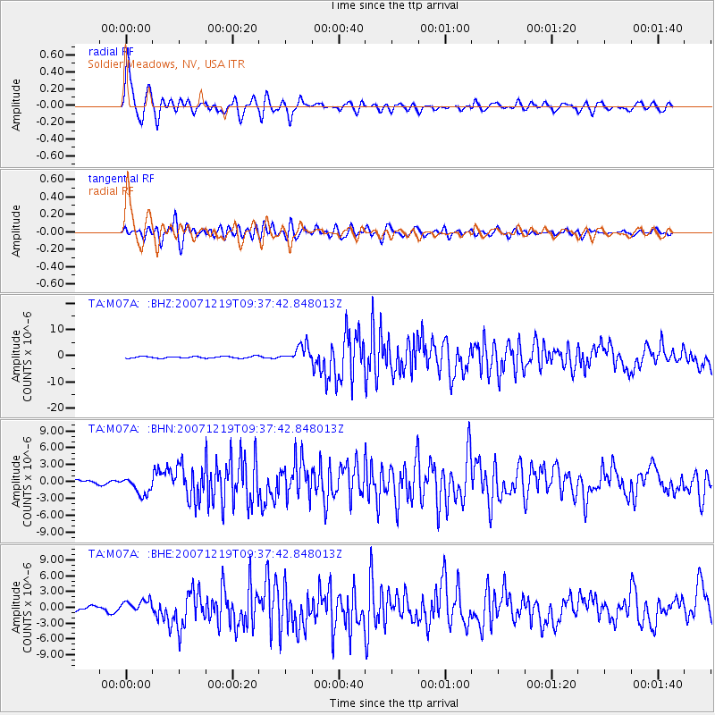
Earthquake location: Andreanof Islands, Aleutian Is.
Earthquake latitude/longitude: 51.4/-179.5
Earthquake time(UTC): 2007/12/19 (353) 09:30:27 GMT
Earthquake Depth: 29 km
Earthquake Magnitude: 6.4 MB, 7.1 MS, 7.1 MW, 7.0 MW
Earthquake Catalog/Contributor: WHDF/NEIC
Network: TA USArray Transportable Network (new EarthScope stations)
Station: M07A Soldier Meadows, NV, USA
Lat/Lon: 41.39 N/119.17 W
Elevation: 1400 m
Distance: 41.7 deg
Az: 79.351 deg
Baz: 305.029 deg
Ray Param: 0.073561944
Estimated Moho Depth: 12.25 km
Estimated Crust Vp/Vs: 1.61
Assumed Crust Vp: 6.276 km/s
Estimated Crust Vs: 3.898 km/s
Estimated Crust Poisson's Ratio: 0.19
Radial Match: 92.98164 %
Radial Bump: 400
Transverse Match: 87.252304 %
Transverse Bump: 400
SOD ConfigId: 2564
Insert Time: 2010-03-06 03:10:48.133 +0000
GWidth: 2.5
Max Bumps: 400
Tol: 0.001

Signal To Noise

ChannelStoNSTALTA
TA:M07A: :BHN:20071219T09:37:42.848013Z4.55246831.6018439E-63.5186275E-7
TA:M07A: :BHE:20071219T09:37:42.848013Z2.83468911.2484898E-64.404327E-7
TA:M07A: :BHZ:20071219T09:37:42.848013Z9.3750763.1944103E-63.4073432E-7
Arrivals
Ps1.3 SECOND
PpPs4.7 SECOND
PsPs/PpSs6.0 SECOND