You are here: Home > Network List > TA - USArray Transportable Network (new EarthScope stations) Stations List
> Station M07A Soldier Meadows, NV, USA > Earthquake Result Viewer
M07A Soldier Meadows, NV, USA - Earthquake Result Viewer
| Earthquake location: |
Kuril Islands |
| Earthquake latitude/longitude: |
45.8/150.1 |
| Earthquake time(UTC): |
2007/09/03 (246) 16:14:53 GMT |
| Earthquake Depth: |
94 km |
| Earthquake Magnitude: |
6.3 MB, 6.2 MW, 6.2 ME |
| Earthquake Catalog/Contributor: |
WHDF/NEIC |
|
| Network: |
TA USArray Transportable Network (new EarthScope stations) |
| Station: |
M07A Soldier Meadows, NV, USA |
| Lat/Lon: |
41.39 N/119.17 W |
| Elevation: |
1400 m |
|
| Distance: |
62.4 deg |
| Az: |
58.134 deg |
| Baz: |
307.899 deg |
| Ray Param: |
0.060020763 |
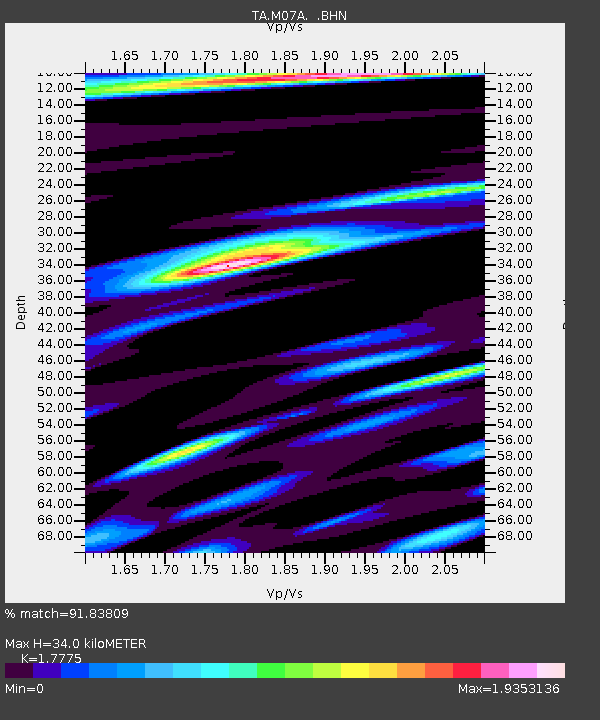
| Estimated Moho Depth: |
34.0 km |
| Estimated Crust Vp/Vs: |
1.78 |
| Assumed Crust Vp: |
6.276 km/s |
| Estimated Crust Vs: |
3.531 km/s |
| Estimated Crust Poisson's Ratio: |
0.27 |
|
| Radial Match: |
91.83809 % |
| Radial Bump: |
400 |
| Transverse Match: |
83.06422 % |
| Transverse Bump: |
400 |
| SOD ConfigId: |
2564 |
| Insert Time: |
2010-03-06 03:11:03.902 +0000 |
| GWidth: |
2.5 |
| Max Bumps: |
400 |
| Tol: |
0.001 |
|
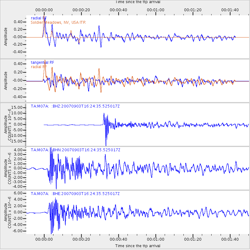
Signal To Noise
| Channel | StoN | STA | LTA |
| TA:M07A: :BHN:20070903T16:24:35.525017Z | 13.407494 | 1.6736539E-6 | 1.2482973E-7 |
| TA:M07A: :BHE:20070903T16:24:35.525017Z | 16.61425 | 2.013791E-6 | 1.2120866E-7 |
| TA:M07A: :BHZ:20070903T16:24:35.525017Z | 41.103096 | 5.5131954E-6 | 1.341309E-7 |
| Arrivals |
| Ps | 4.4 SECOND |
| PpPs | 14 SECOND |
| PsPs/PpSs | 19 SECOND |


