You are here: Home > Network List > TA - USArray Transportable Network (new EarthScope stations) Stations List
> Station M07A Soldier Meadows, NV, USA > Earthquake Result Viewer
M07A Soldier Meadows, NV, USA - Earthquake Result Viewer
| Earthquake location: |
Vanuatu Islands |
| Earthquake latitude/longitude: |
-15.6/167.7 |
| Earthquake time(UTC): |
2007/08/01 (213) 17:08:51 GMT |
| Earthquake Depth: |
120 km |
| Earthquake Magnitude: |
6.2 MB, 7.2 MW, 7.2 MW |
| Earthquake Catalog/Contributor: |
WHDF/NEIC |
|
| Network: |
TA USArray Transportable Network (new EarthScope stations) |
| Station: |
M07A Soldier Meadows, NV, USA |
| Lat/Lon: |
41.39 N/119.17 W |
| Elevation: |
1400 m |
|
| Distance: |
88.0 deg |
| Az: |
46.1 deg |
| Baz: |
247.341 deg |
| Ray Param: |
0.04262412 |
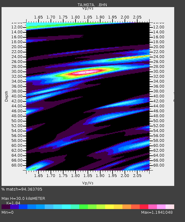
| Estimated Moho Depth: |
30.0 km |
| Estimated Crust Vp/Vs: |
1.84 |
| Assumed Crust Vp: |
6.276 km/s |
| Estimated Crust Vs: |
3.411 km/s |
| Estimated Crust Poisson's Ratio: |
0.29 |
|
| Radial Match: |
94.363785 % |
| Radial Bump: |
368 |
| Transverse Match: |
89.812935 % |
| Transverse Bump: |
400 |
| SOD ConfigId: |
2564 |
| Insert Time: |
2010-03-06 03:11:20.569 +0000 |
| GWidth: |
2.5 |
| Max Bumps: |
400 |
| Tol: |
0.001 |
|

Signal To Noise
| Channel | StoN | STA | LTA |
| TA:M07A: :BHN:20070801T17:20:56.975012Z | 0.76194763 | 6.5964876E-8 | 8.6574026E-8 |
| TA:M07A: :BHE:20070801T17:20:56.975012Z | 2.1010365 | 1.7078908E-7 | 8.1288E-8 |
| TA:M07A: :BHZ:20070801T17:20:56.975012Z | 5.508541 | 6.200882E-7 | 1.125685E-7 |
| Arrivals |
| Ps | 4.1 SECOND |
| PpPs | 13 SECOND |
| PsPs/PpSs | 17 SECOND |


