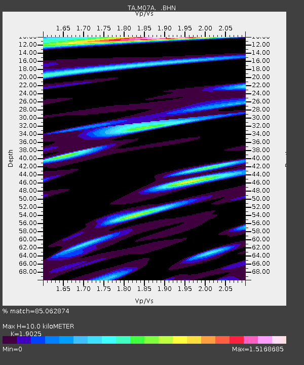
M07A Soldier Meadows, NV, USA - Earthquake Result Viewer
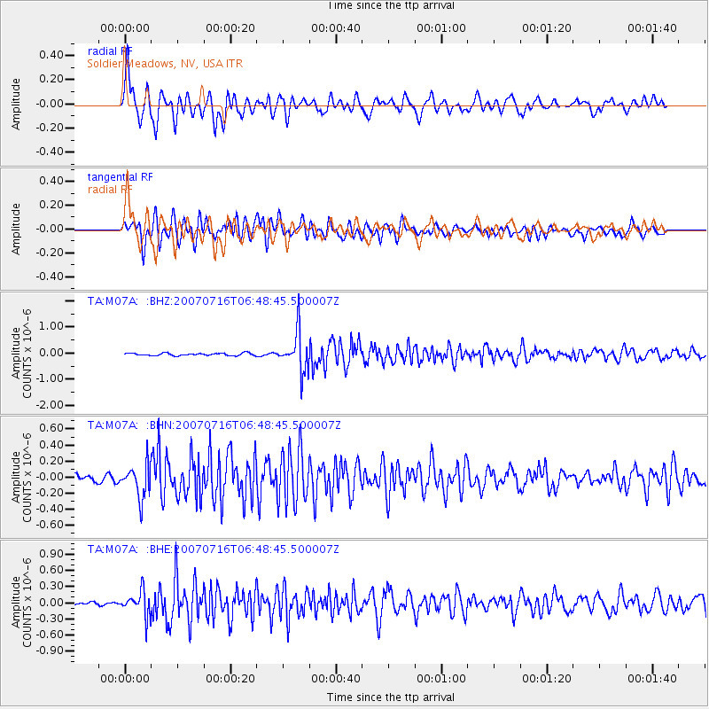
Earthquake location: Near West Coast Of Honshu, Japan
Earthquake latitude/longitude: 37.5/138.5
Earthquake time(UTC): 2007/07/16 (197) 06:37:40 GMT
Earthquake Depth: 15 km
Earthquake Magnitude: 5.7 MB, 5.1 MS, 5.7 MW, 5.6 MW
Earthquake Catalog/Contributor: WHDF/NEIC
Network: TA USArray Transportable Network (new EarthScope stations)
Station: M07A Soldier Meadows, NV, USA
Lat/Lon: 41.39 N/119.17 W
Elevation: 1400 m
Distance: 74.3 deg
Az: 49.783 deg
Baz: 306.186 deg
Ray Param: 0.052439384
Estimated Moho Depth: 10.0 km
Estimated Crust Vp/Vs: 1.90
Assumed Crust Vp: 6.276 km/s
Estimated Crust Vs: 3.299 km/s
Estimated Crust Poisson's Ratio: 0.31
Radial Match: 85.062874 %
Radial Bump: 400
Transverse Match: 85.25083 %
Transverse Bump: 400
SOD ConfigId: 2564
Insert Time: 2010-03-06 03:11:30.323 +0000
GWidth: 2.5
Max Bumps: 400
Tol: 0.001

Signal To Noise

ChannelStoNSTALTA
TA:M07A: :BHN:20070716T06:48:45.500007Z4.41197632.0432573E-74.631161E-8
TA:M07A: :BHE:20070716T06:48:45.500007Z3.47644352.2991323E-76.6134604E-8
TA:M07A: :BHZ:20070716T06:48:45.500007Z16.157067.6805384E-74.753673E-8
Arrivals
Ps1.5 SECOND
PpPs4.5 SECOND
PsPs/PpSs6.0 SECOND