You are here: Home > Network List > TA - USArray Transportable Network (new EarthScope stations) Stations List
> Station M07A Soldier Meadows, NV, USA > Earthquake Result Viewer
M07A Soldier Meadows, NV, USA - Earthquake Result Viewer
| Earthquake location: |
East Of Kuril Islands |
| Earthquake latitude/longitude: |
46.2/154.4 |
| Earthquake time(UTC): |
2006/12/07 (341) 19:10:21 GMT |
| Earthquake Depth: |
16 km |
| Earthquake Magnitude: |
6.3 MB, 6.1 MS, 6.3 MW, 6.3 MW |
| Earthquake Catalog/Contributor: |
WHDF/NEIC |
|
| Network: |
TA USArray Transportable Network (new EarthScope stations) |
| Station: |
M07A Soldier Meadows, NV, USA |
| Lat/Lon: |
41.39 N/119.17 W |
| Elevation: |
1400 m |
|
| Distance: |
59.6 deg |
| Az: |
60.534 deg |
| Baz: |
306.452 deg |
| Ray Param: |
0.06206328 |
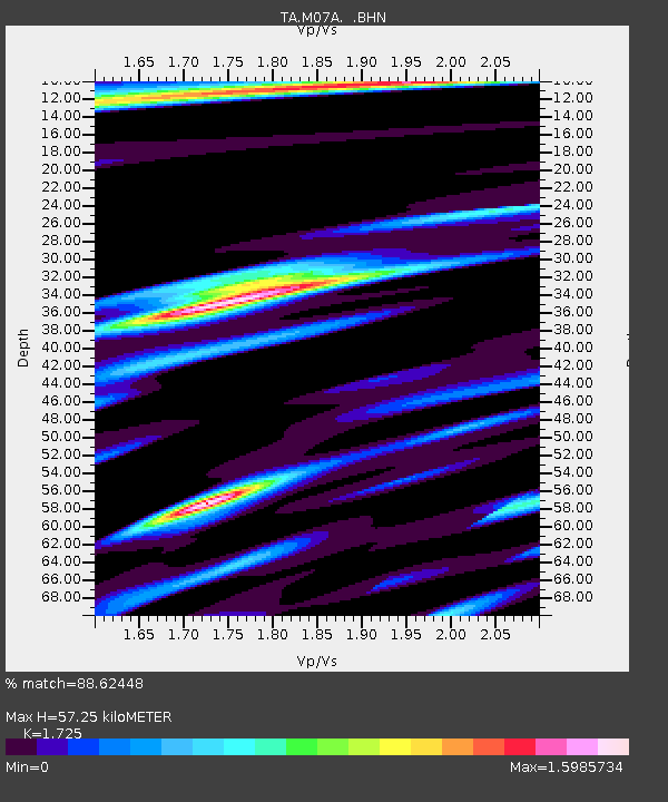
| Estimated Moho Depth: |
57.25 km |
| Estimated Crust Vp/Vs: |
1.73 |
| Assumed Crust Vp: |
6.276 km/s |
| Estimated Crust Vs: |
3.638 km/s |
| Estimated Crust Poisson's Ratio: |
0.25 |
|
| Radial Match: |
88.62448 % |
| Radial Bump: |
400 |
| Transverse Match: |
78.06678 % |
| Transverse Bump: |
400 |
| SOD ConfigId: |
2564 |
| Insert Time: |
2010-03-06 03:11:51.622 +0000 |
| GWidth: |
2.5 |
| Max Bumps: |
400 |
| Tol: |
0.001 |
|

Signal To Noise
| Channel | StoN | STA | LTA |
| TA:M07A: :BHN:20061207T19:19:53.750024Z | 1.4040302 | 5.130773E-7 | 3.654318E-7 |
| TA:M07A: :BHE:20061207T19:19:53.750024Z | 2.3418856 | 6.118619E-7 | 2.612689E-7 |
| TA:M07A: :BHZ:20061207T19:19:53.750024Z | 7.7444706 | 1.5928829E-6 | 2.0568002E-7 |
| Arrivals |
| Ps | 6.9 SECOND |
| PpPs | 24 SECOND |
| PsPs/PpSs | 31 SECOND |


