You are here: Home > Network List > TA - USArray Transportable Network (new EarthScope stations) Stations List
> Station L15K Ungalak Mountain, AK, USA > Earthquake Result Viewer
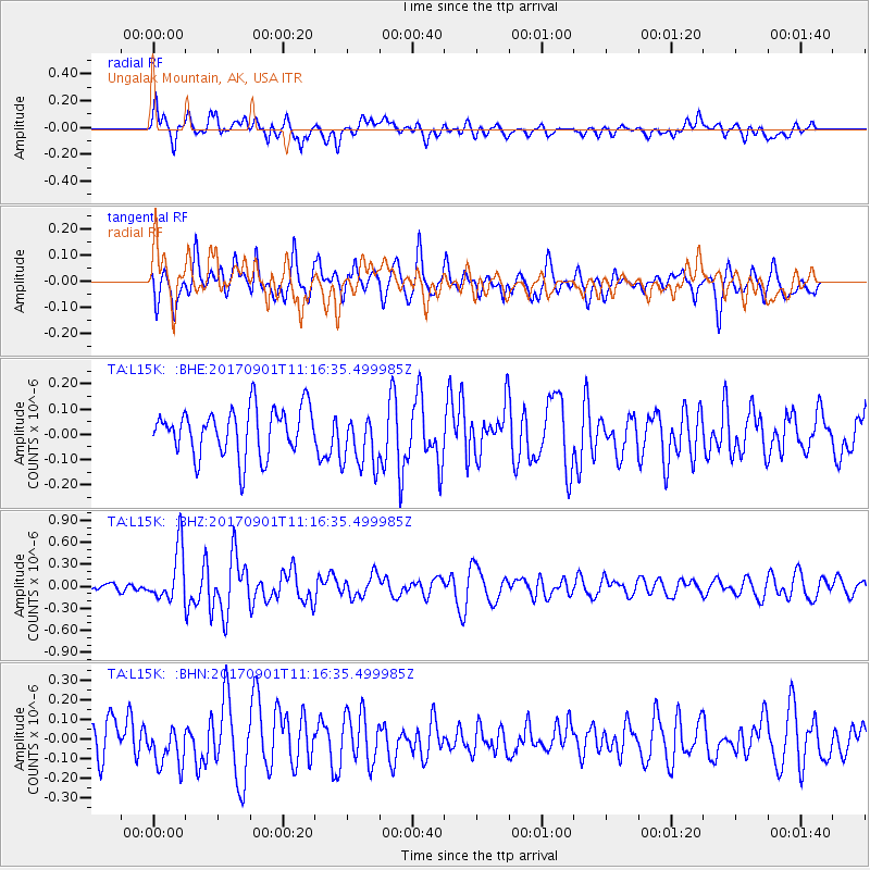
L15K Ungalak Mountain, AK, USA - Earthquake Result Viewer
*The percent match for this event was below the threshold and hence no stack was calculated.
| Earthquake location: |
Reykjanes Ridge |
| Earthquake latitude/longitude: |
57.0/-34.0 |
| Earthquake time(UTC): |
2017/09/01 (244) 11:07:37 GMT |
| Earthquake Depth: |
10 km |
| Earthquake Magnitude: |
5.7 Mww |
| Earthquake Catalog/Contributor: |
NEIC PDE/us |
|
| Network: |
TA USArray Transportable Network (new EarthScope stations) |
| Station: |
L15K Ungalak Mountain, AK, USA |
| Lat/Lon: |
61.68 N/161.49 W |
| Elevation: |
219 m |
|
| Distance: |
54.7 deg |
| Az: |
332.373 deg |
| Baz: |
32.1 deg |
| Ray Param: |
$rayparam |
*The percent match for this event was below the threshold and hence was not used in the summary stack. |
|
| Radial Match: |
60.234184 % |
| Radial Bump: |
400 |
| Transverse Match: |
61.174095 % |
| Transverse Bump: |
400 |
| SOD ConfigId: |
13570011 |
| Insert Time: |
2019-04-28 16:17:17.821 +0000 |
| GWidth: |
2.5 |
| Max Bumps: |
400 |
| Tol: |
0.001 |
|
Signal To Noise
| Channel | StoN | STA | LTA |
| TA:L15K: :BHZ:20170901T11:16:35.499985Z | 3.6782563 | 3.6236997E-7 | 9.851678E-8 |
| TA:L15K: :BHN:20170901T11:16:35.499985Z | 1.2734207 | 1.01944984E-7 | 8.005602E-8 |
| TA:L15K: :BHE:20170901T11:16:35.499985Z | 1.2159529 | 1.131393E-7 | 9.304579E-8 |
| Arrivals |
| Ps | |
| PpPs | |
| PsPs/PpSs | |


