You are here: Home > Network List > TA - USArray Transportable Network (new EarthScope stations) Stations List
> Station MDND Maddock, ND, USA > Earthquake Result Viewer
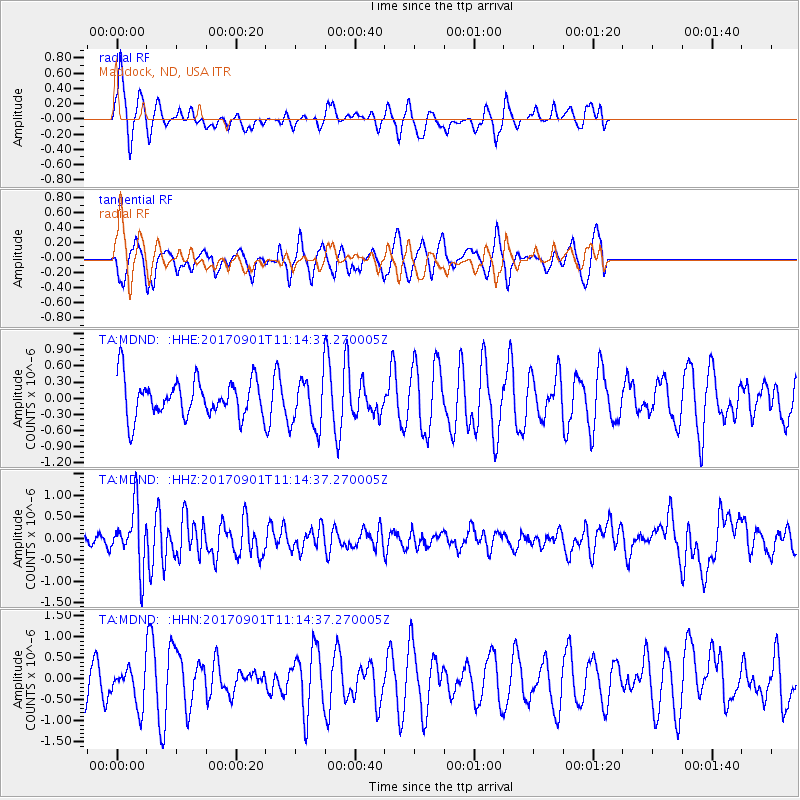
MDND Maddock, ND, USA - Earthquake Result Viewer
*The percent match for this event was below the threshold and hence no stack was calculated.
| Earthquake location: |
Reykjanes Ridge |
| Earthquake latitude/longitude: |
57.0/-34.0 |
| Earthquake time(UTC): |
2017/09/01 (244) 11:07:37 GMT |
| Earthquake Depth: |
10 km |
| Earthquake Magnitude: |
5.7 Mww |
| Earthquake Catalog/Contributor: |
NEIC PDE/us |
|
| Network: |
TA USArray Transportable Network (new EarthScope stations) |
| Station: |
MDND Maddock, ND, USA |
| Lat/Lon: |
47.85 N/99.60 W |
| Elevation: |
479 m |
|
| Distance: |
39.5 deg |
| Az: |
285.553 deg |
| Baz: |
51.411 deg |
| Ray Param: |
$rayparam |
*The percent match for this event was below the threshold and hence was not used in the summary stack. |
|
| Radial Match: |
51.35423 % |
| Radial Bump: |
322 |
| Transverse Match: |
46.302574 % |
| Transverse Bump: |
396 |
| SOD ConfigId: |
13570011 |
| Insert Time: |
2019-04-28 16:17:31.325 +0000 |
| GWidth: |
2.5 |
| Max Bumps: |
400 |
| Tol: |
0.001 |
|
Signal To Noise
| Channel | StoN | STA | LTA |
| TA:MDND: :HHZ:20170901T11:14:37.270005Z | 4.649291 | 6.7810544E-7 | 1.4585136E-7 |
| TA:MDND: :HHN:20170901T11:14:37.270005Z | 0.6618853 | 4.6845756E-7 | 7.077624E-7 |
| TA:MDND: :HHE:20170901T11:14:37.270005Z | 1.3547459 | 4.658051E-7 | 3.4383208E-7 |
| Arrivals |
| Ps | |
| PpPs | |
| PsPs/PpSs | |


