M07A Soldier Meadows, NV, USA - Earthquake Result Viewer
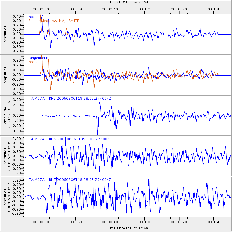
Earthquake location: Bonin Islands, Japan Region
Earthquake latitude/longitude: 26.1/144.0
Earthquake time(UTC): 2006/08/06 (218) 18:16:40 GMT
Earthquake Depth: 23 km
Earthquake Magnitude: 6.0 MB, 5.6 MS, 5.8 MW, 5.8 MW
Earthquake Catalog/Contributor: WHDF/NEIC
Network: TA USArray Transportable Network (new EarthScope stations)
Station: M07A Soldier Meadows, NV, USA
Lat/Lon: 41.39 N/119.17 W
Elevation: 1400 m
Distance: 78.0 deg
Az: 49.803 deg
Baz: 294.126 deg
Ray Param: 0.049920812
Estimated Moho Depth: 10.0 km
Estimated Crust Vp/Vs: 1.90
Assumed Crust Vp: 6.276 km/s
Estimated Crust Vs: 3.299 km/s
Estimated Crust Poisson's Ratio: 0.31
Radial Match: 86.455795 %
Radial Bump: 400
Transverse Match: 80.44041 %
Transverse Bump: 400
SOD ConfigId: 2665
Insert Time: 2010-03-06 03:12:25.552 +0000
GWidth: 2.5
Max Bumps: 400
Tol: 0.001

Signal To Noise

ChannelStoNSTALTA
TA:M07A: :BHN:20060806T18:28:05.274004Z2.12717681.7327626E-78.145833E-8
TA:M07A: :BHE:20060806T18:28:05.274004Z4.1340584.5835048E-71.1087181E-7
TA:M07A: :BHZ:20060806T18:28:05.274004Z12.6446071.3953919E-61.1035471E-7
Arrivals
Ps1.5 SECOND
PpPs4.5 SECOND
PsPs/PpSs6.0 SECOND