You are here: Home > Network List > TA - USArray Transportable Network (new EarthScope stations) Stations List
> Station TPFO Pinon Flats, CA, USA > Earthquake Result Viewer
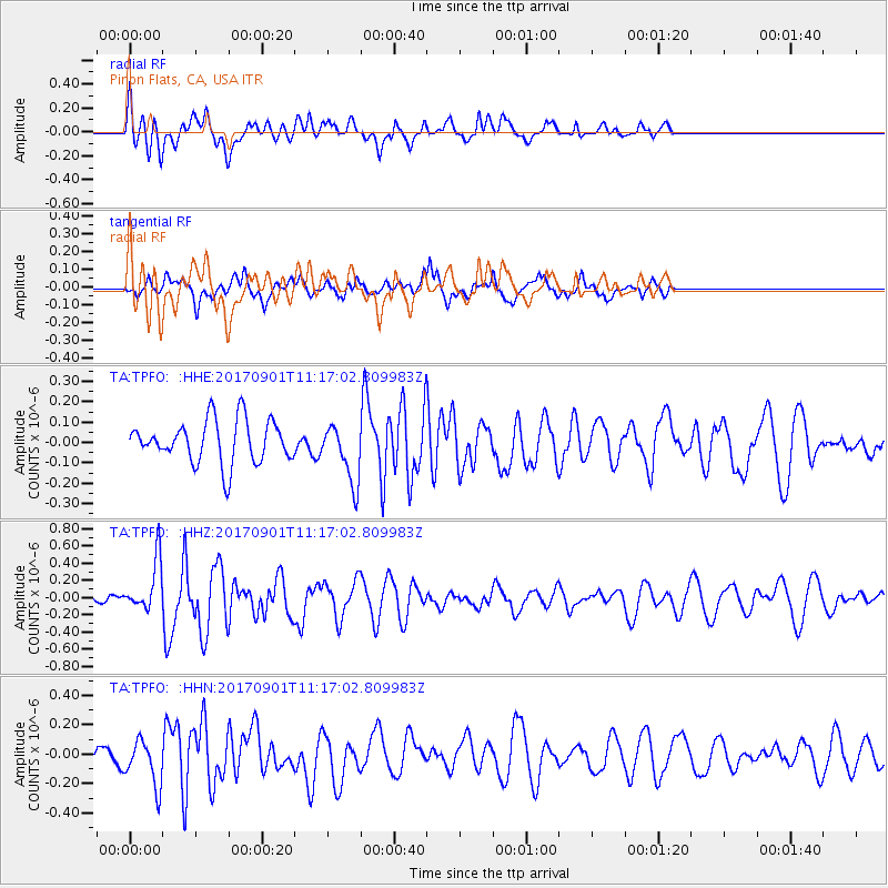
TPFO Pinon Flats, CA, USA - Earthquake Result Viewer
*The percent match for this event was below the threshold and hence no stack was calculated.
| Earthquake location: |
Reykjanes Ridge |
| Earthquake latitude/longitude: |
57.0/-34.0 |
| Earthquake time(UTC): |
2017/09/01 (244) 11:07:37 GMT |
| Earthquake Depth: |
10 km |
| Earthquake Magnitude: |
5.7 Mww |
| Earthquake Catalog/Contributor: |
NEIC PDE/us |
|
| Network: |
TA USArray Transportable Network (new EarthScope stations) |
| Station: |
TPFO Pinon Flats, CA, USA |
| Lat/Lon: |
33.61 N/116.45 W |
| Elevation: |
1275 m |
|
| Distance: |
58.6 deg |
| Az: |
284.176 deg |
| Baz: |
39.412 deg |
| Ray Param: |
$rayparam |
*The percent match for this event was below the threshold and hence was not used in the summary stack. |
|
| Radial Match: |
58.743793 % |
| Radial Bump: |
400 |
| Transverse Match: |
57.475338 % |
| Transverse Bump: |
400 |
| SOD ConfigId: |
13570011 |
| Insert Time: |
2019-04-28 16:18:03.841 +0000 |
| GWidth: |
2.5 |
| Max Bumps: |
400 |
| Tol: |
0.001 |
|
Signal To Noise
| Channel | StoN | STA | LTA |
| TA:TPFO: :HHZ:20170901T11:17:02.809983Z | 2.6226916 | 3.0048585E-7 | 1.14571556E-7 |
| TA:TPFO: :HHN:20170901T11:17:02.809983Z | 1.9912821 | 1.5517523E-7 | 7.79273E-8 |
| TA:TPFO: :HHE:20170901T11:17:02.809983Z | 1.3889203 | 1.4433768E-7 | 1.03920776E-7 |
| Arrivals |
| Ps | |
| PpPs | |
| PsPs/PpSs | |


