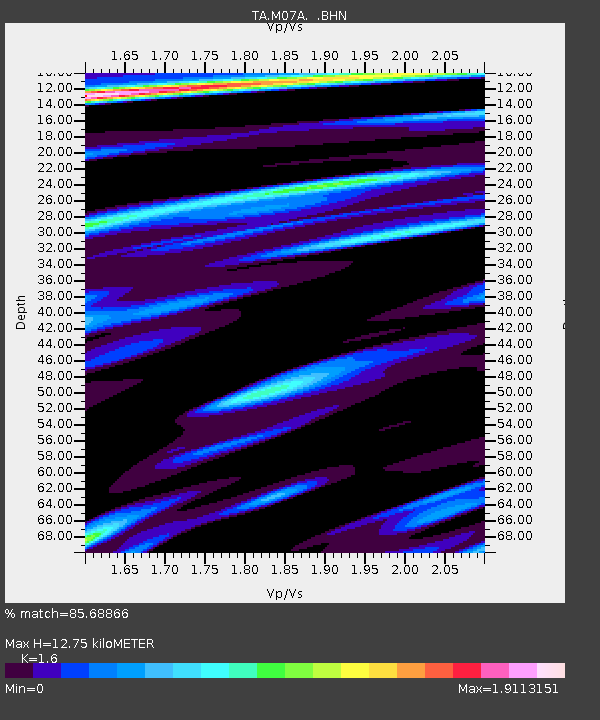
M07A Soldier Meadows, NV, USA - Earthquake Result Viewer

Earthquake location: Off Coast Of Chiapas, Mexico
Earthquake latitude/longitude: 15.0/-94.2
Earthquake time(UTC): 2006/06/27 (178) 13:03:12 GMT
Earthquake Depth: 29 km
Earthquake Magnitude: 5.4 MB, 5.5 MS, 5.8 MW, 5.8 MW
Earthquake Catalog/Contributor: WHDF/NEIC
Network: TA USArray Transportable Network (new EarthScope stations)
Station: M07A Soldier Meadows, NV, USA
Lat/Lon: 41.39 N/119.17 W
Elevation: 1400 m
Distance: 34.1 deg
Az: 325.45 deg
Baz: 133.24 deg
Ray Param: 0.07786348
Estimated Moho Depth: 12.75 km
Estimated Crust Vp/Vs: 1.60
Assumed Crust Vp: 6.276 km/s
Estimated Crust Vs: 3.922 km/s
Estimated Crust Poisson's Ratio: 0.18
Radial Match: 85.68866 %
Radial Bump: 394
Transverse Match: 63.015717 %
Transverse Bump: 400
SOD ConfigId: 2665
Insert Time: 2010-03-06 03:12:34.383 +0000
GWidth: 2.5
Max Bumps: 400
Tol: 0.001

Signal To Noise

ChannelStoNSTALTA
TA:M07A: :BHN:20060627T13:09:23.650Z6.30268765.141197E-78.157151E-8
TA:M07A: :BHE:20060627T13:09:23.650Z2.4419842.67081E-71.0937049E-7
TA:M07A: :BHZ:20060627T13:09:23.650Z4.83772857.388103E-71.5271841E-7
Arrivals
Ps1.3 SECOND
PpPs4.9 SECOND
PsPs/PpSs6.2 SECOND