M07A Soldier Meadows, NV, USA - Earthquake Result Viewer
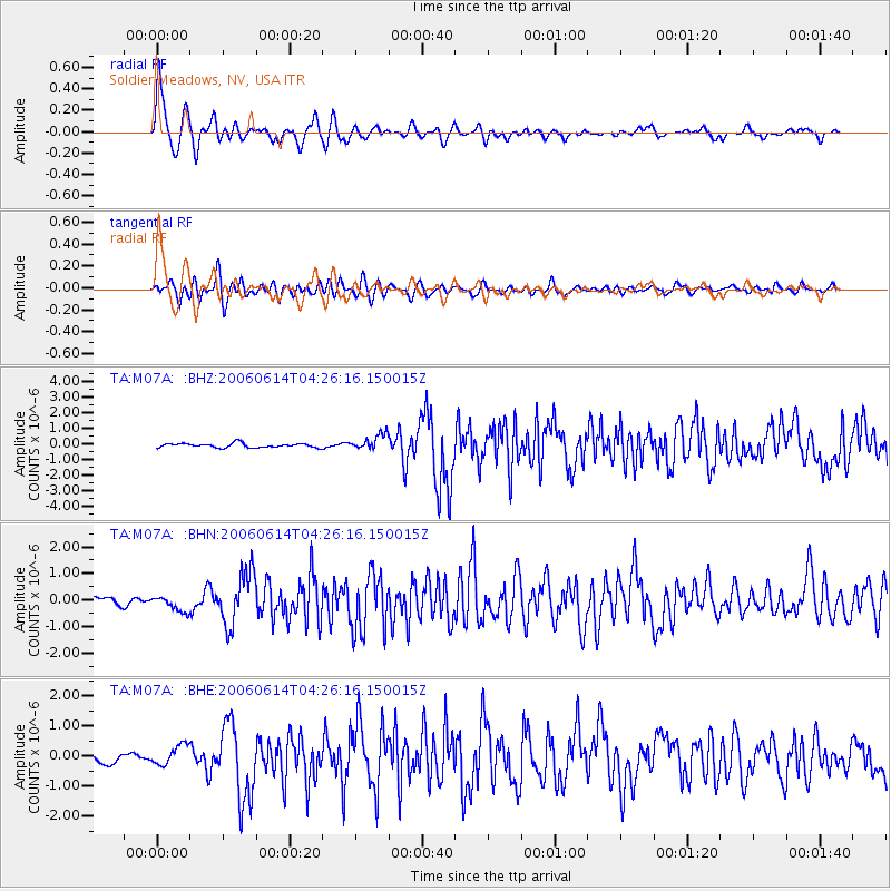
Earthquake location: Rat Islands, Aleutian Islands
Earthquake latitude/longitude: 51.8/177.1
Earthquake time(UTC): 2006/06/14 (165) 04:18:42 GMT
Earthquake Depth: 14 km
Earthquake Magnitude: 5.9 MB, 6.4 MS, 6.4 MW, 6.4 MW
Earthquake Catalog/Contributor: WHDF/NEIC
Network: TA USArray Transportable Network (new EarthScope stations)
Station: M07A Soldier Meadows, NV, USA
Lat/Lon: 41.39 N/119.17 W
Elevation: 1400 m
Distance: 43.7 deg
Az: 77.571 deg
Baz: 306.217 deg
Ray Param: 0.072364144
Estimated Moho Depth: 12.25 km
Estimated Crust Vp/Vs: 1.61
Assumed Crust Vp: 6.276 km/s
Estimated Crust Vs: 3.904 km/s
Estimated Crust Poisson's Ratio: 0.18
Radial Match: 91.00914 %
Radial Bump: 400
Transverse Match: 81.25347 %
Transverse Bump: 400
SOD ConfigId: 5745
Insert Time: 2010-03-06 03:12:41.367 +0000
GWidth: 2.5
Max Bumps: 400
Tol: 0.001

Signal To Noise

ChannelStoNSTALTA
TA:M07A: :BHN:20060614T04:26:16.150015Z2.43168693.0122675E-71.2387562E-7
TA:M07A: :BHE:20060614T04:26:16.150015Z2.05305243.3323226E-71.6231066E-7
TA:M07A: :BHZ:20060614T04:26:16.150015Z3.70563174.9847523E-71.3451829E-7
Arrivals
Ps1.3 SECOND
PpPs4.7 SECOND
PsPs/PpSs6.0 SECOND