You are here: Home > Network List > UW - Pacific Northwest Regional Seismic Network Stations List
> Station UMAT Pilot Rock, OR, USA > Earthquake Result Viewer
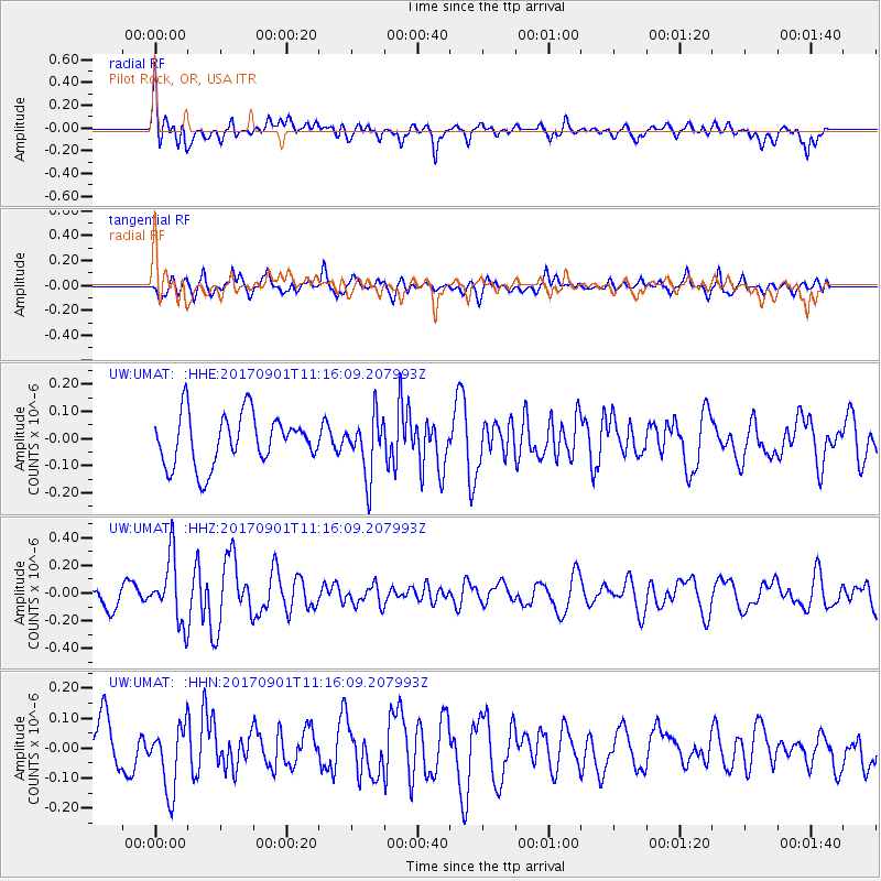
UMAT Pilot Rock, OR, USA - Earthquake Result Viewer
*The percent match for this event was below the threshold and hence no stack was calculated.
| Earthquake location: |
Reykjanes Ridge |
| Earthquake latitude/longitude: |
57.0/-34.0 |
| Earthquake time(UTC): |
2017/09/01 (244) 11:07:37 GMT |
| Earthquake Depth: |
10 km |
| Earthquake Magnitude: |
5.7 Mww |
| Earthquake Catalog/Contributor: |
NEIC PDE/us |
|
| Network: |
UW Pacific Northwest Regional Seismic Network |
| Station: |
UMAT Pilot Rock, OR, USA |
| Lat/Lon: |
45.29 N/118.96 W |
| Elevation: |
1318 m |
|
| Distance: |
51.2 deg |
| Az: |
295.467 deg |
| Baz: |
44.344 deg |
| Ray Param: |
$rayparam |
*The percent match for this event was below the threshold and hence was not used in the summary stack. |
|
| Radial Match: |
56.63763 % |
| Radial Bump: |
400 |
| Transverse Match: |
56.781 % |
| Transverse Bump: |
400 |
| SOD ConfigId: |
13570011 |
| Insert Time: |
2019-04-28 16:18:58.473 +0000 |
| GWidth: |
2.5 |
| Max Bumps: |
400 |
| Tol: |
0.001 |
|
Signal To Noise
| Channel | StoN | STA | LTA |
| UW:UMAT: :HHZ:20170901T11:16:09.207993Z | 2.6214387 | 2.3330946E-7 | 8.900054E-8 |
| UW:UMAT: :HHN:20170901T11:16:09.207993Z | 1.1198462 | 1.0864564E-7 | 9.701835E-8 |
| UW:UMAT: :HHE:20170901T11:16:09.207993Z | 1.1716459 | 1.09295996E-7 | 9.328416E-8 |
| Arrivals |
| Ps | |
| PpPs | |
| PsPs/PpSs | |


