You are here: Home > Network List > TA - USArray Transportable Network (new EarthScope stations) Stations List
> Station M07A Soldier Meadows, NV, USA > Earthquake Result Viewer
M07A Soldier Meadows, NV, USA - Earthquake Result Viewer
| Earthquake location: |
Tonga Islands |
| Earthquake latitude/longitude: |
-19.8/-174.7 |
| Earthquake time(UTC): |
2006/05/05 (125) 06:16:20 GMT |
| Earthquake Depth: |
35 km |
| Earthquake Magnitude: |
5.6 MB, 5.8 MS, 5.9 MW, 5.8 MW |
| Earthquake Catalog/Contributor: |
WHDF/NEIC |
|
| Network: |
TA USArray Transportable Network (new EarthScope stations) |
| Station: |
M07A Soldier Meadows, NV, USA |
| Lat/Lon: |
41.39 N/119.17 W |
| Elevation: |
1400 m |
|
| Distance: |
79.7 deg |
| Az: |
39.063 deg |
| Baz: |
232.039 deg |
| Ray Param: |
0.04875038 |
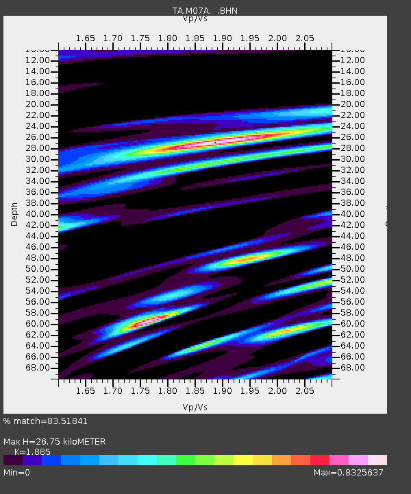
| Estimated Moho Depth: |
26.75 km |
| Estimated Crust Vp/Vs: |
1.88 |
| Assumed Crust Vp: |
6.276 km/s |
| Estimated Crust Vs: |
3.329 km/s |
| Estimated Crust Poisson's Ratio: |
0.30 |
|
| Radial Match: |
83.51841 % |
| Radial Bump: |
400 |
| Transverse Match: |
75.95712 % |
| Transverse Bump: |
400 |
| SOD ConfigId: |
2669 |
| Insert Time: |
2010-03-06 03:12:48.592 +0000 |
| GWidth: |
2.5 |
| Max Bumps: |
400 |
| Tol: |
0.001 |
|

Signal To Noise
| Channel | StoN | STA | LTA |
| TA:M07A: :BHN:20060505T06:27:53.224021Z | 0.8862196 | 1.2059618E-7 | 1.3607935E-7 |
| TA:M07A: :BHE:20060505T06:27:53.224021Z | 0.96329653 | 1.8568856E-7 | 1.9276366E-7 |
| TA:M07A: :BHZ:20060505T06:27:53.224021Z | 3.9702156 | 5.2399275E-7 | 1.3198093E-7 |
| Arrivals |
| Ps | 3.9 SECOND |
| PpPs | 12 SECOND |
| PsPs/PpSs | 16 SECOND |


