You are here: Home > Network List > TA - USArray Transportable Network (new EarthScope stations) Stations List
> Station M07A Soldier Meadows, NV, USA > Earthquake Result Viewer
M07A Soldier Meadows, NV, USA - Earthquake Result Viewer
| Earthquake location: |
Fiji Islands Region |
| Earthquake latitude/longitude: |
-16.5/177.0 |
| Earthquake time(UTC): |
2006/04/07 (097) 08:30:45 GMT |
| Earthquake Depth: |
22 km |
| Earthquake Magnitude: |
5.9 MB, 6.4 MS, 6.4 MW, 6.4 MW |
| Earthquake Catalog/Contributor: |
WHDF/NEIC |
|
| Network: |
TA USArray Transportable Network (new EarthScope stations) |
| Station: |
M07A Soldier Meadows, NV, USA |
| Lat/Lon: |
41.39 N/119.17 W |
| Elevation: |
1400 m |
|
| Distance: |
82.4 deg |
| Az: |
42.95 deg |
| Baz: |
240.289 deg |
| Ray Param: |
0.0468718 |
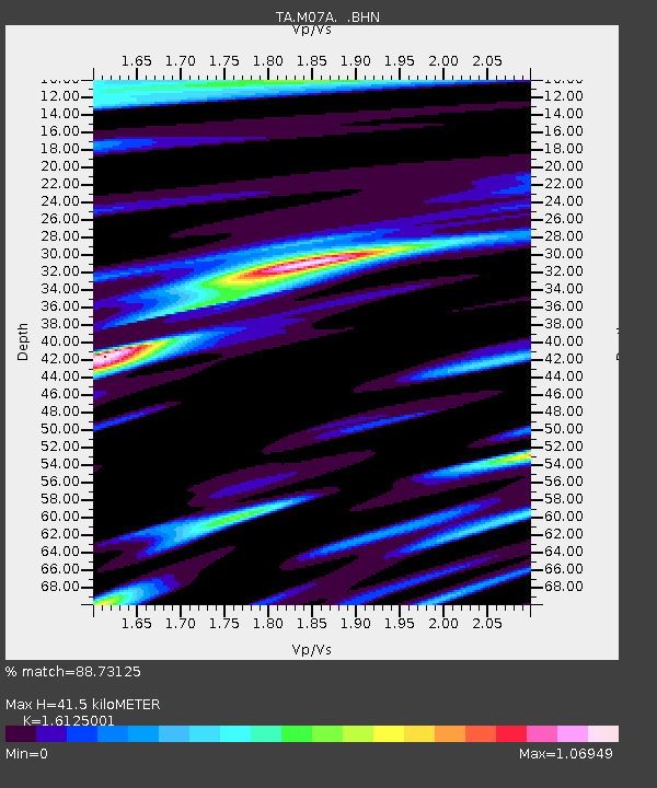
| Estimated Moho Depth: |
41.5 km |
| Estimated Crust Vp/Vs: |
1.61 |
| Assumed Crust Vp: |
6.276 km/s |
| Estimated Crust Vs: |
3.892 km/s |
| Estimated Crust Poisson's Ratio: |
0.19 |
|
| Radial Match: |
88.73125 % |
| Radial Bump: |
400 |
| Transverse Match: |
86.232506 % |
| Transverse Bump: |
400 |
| SOD ConfigId: |
2669 |
| Insert Time: |
2010-03-06 03:12:57.343 +0000 |
| GWidth: |
2.5 |
| Max Bumps: |
400 |
| Tol: |
0.001 |
|

Signal To Noise
| Channel | StoN | STA | LTA |
| TA:M07A: :BHN:20060407T08:42:34.925005Z | 1.2362295 | 1.8220197E-7 | 1.4738522E-7 |
| TA:M07A: :BHE:20060407T08:42:34.925005Z | 1.3901678 | 1.7224082E-7 | 1.238993E-7 |
| TA:M07A: :BHZ:20060407T08:42:34.925005Z | 3.5624995 | 4.0163525E-7 | 1.1273973E-7 |
| Arrivals |
| Ps | 4.2 SECOND |
| PpPs | 17 SECOND |
| PsPs/PpSs | 21 SECOND |


