You are here: Home > Network List > IU - Global Seismograph Network (GSN - IRIS/USGS) Stations List
> Station CTAO Charters Towers, Australia > Earthquake Result Viewer
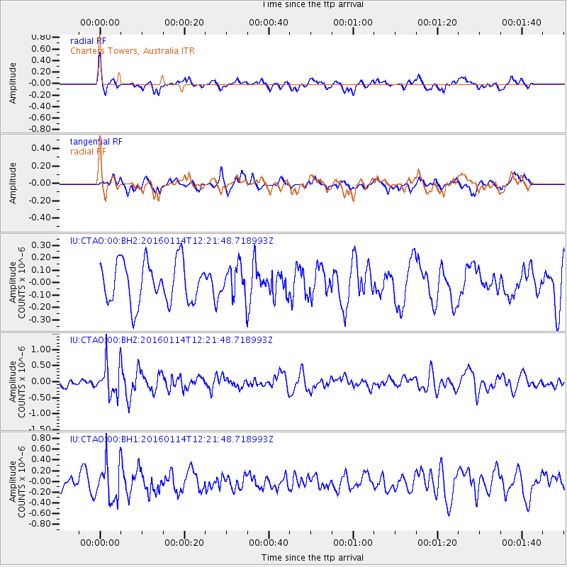
CTAO Charters Towers, Australia - Earthquake Result Viewer
*The percent match for this event was below the threshold and hence no stack was calculated.
| Earthquake location: |
Macquarie Island Region |
| Earthquake latitude/longitude: |
-53.3/159.8 |
| Earthquake time(UTC): |
2016/01/14 (014) 12:15:29 GMT |
| Earthquake Depth: |
10 km |
| Earthquake Magnitude: |
5.5 MWW, 5.4 MWB, 5.5 MWC |
| Earthquake Catalog/Contributor: |
NEIC PDE/NEIC COMCAT |
|
| Network: |
IU Global Seismograph Network (GSN - IRIS/USGS) |
| Station: |
CTAO Charters Towers, Australia |
| Lat/Lon: |
20.09 S/146.25 E |
| Elevation: |
357 m |
|
| Distance: |
34.7 deg |
| Az: |
337.341 deg |
| Baz: |
165.745 deg |
| Ray Param: |
$rayparam |
*The percent match for this event was below the threshold and hence was not used in the summary stack. |
|
| Radial Match: |
66.39078 % |
| Radial Bump: |
400 |
| Transverse Match: |
44.633408 % |
| Transverse Bump: |
400 |
| SOD ConfigId: |
1427151 |
| Insert Time: |
2016-02-16 09:51:42.558 +0000 |
| GWidth: |
2.5 |
| Max Bumps: |
400 |
| Tol: |
0.001 |
|
Signal To Noise
| Channel | StoN | STA | LTA |
| IU:CTAO:00:BHZ:20160114T12:21:48.718993Z | 2.9067132 | 5.088326E-7 | 1.7505428E-7 |
| IU:CTAO:00:BH1:20160114T12:21:48.718993Z | 2.427722 | 3.5261863E-7 | 1.452467E-7 |
| IU:CTAO:00:BH2:20160114T12:21:48.718993Z | 0.7863053 | 1.2955863E-7 | 1.6476886E-7 |
| Arrivals |
| Ps | |
| PpPs | |
| PsPs/PpSs | |


