You are here: Home > Network List > TA - USArray Transportable Network (new EarthScope stations) Stations List
> Station J09A Fry Pan Ranch, Harper, OR, USA > Earthquake Result Viewer
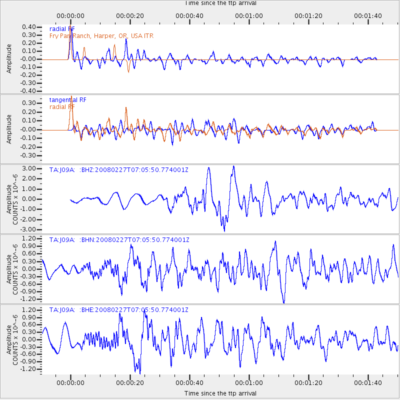
J09A Fry Pan Ranch, Harper, OR, USA - Earthquake Result Viewer
| Earthquake location: |
Bonin Islands, Japan Region |
| Earthquake latitude/longitude: |
26.8/142.4 |
| Earthquake time(UTC): |
2008/02/27 (058) 06:54:20 GMT |
| Earthquake Depth: |
15 km |
| Earthquake Magnitude: |
5.8 MB, 6.1 MS, 6.2 MW, 6.2 MW |
| Earthquake Catalog/Contributor: |
WHDF/NEIC |
|
| Network: |
TA USArray Transportable Network (new EarthScope stations) |
| Station: |
J09A Fry Pan Ranch, Harper, OR, USA |
| Lat/Lon: |
43.35 N/117.75 W |
| Elevation: |
1303 m |
|
| Distance: |
78.7 deg |
| Az: |
47.142 deg |
| Baz: |
296.103 deg |
| Ray Param: |
0.0494509 |
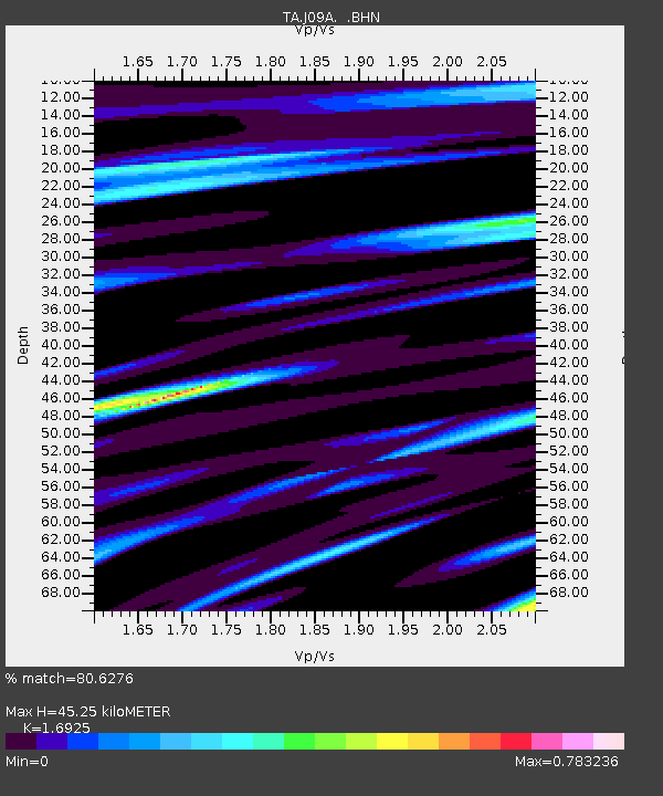
| Estimated Moho Depth: |
45.25 km |
| Estimated Crust Vp/Vs: |
1.69 |
| Assumed Crust Vp: |
6.291 km/s |
| Estimated Crust Vs: |
3.717 km/s |
| Estimated Crust Poisson's Ratio: |
0.23 |
|
| Radial Match: |
80.6276 % |
| Radial Bump: |
400 |
| Transverse Match: |
70.36744 % |
| Transverse Bump: |
400 |
| SOD ConfigId: |
2564 |
| Insert Time: |
2010-03-06 03:13:08.677 +0000 |
| GWidth: |
2.5 |
| Max Bumps: |
400 |
| Tol: |
0.001 |
|
Signal To Noise
| Channel | StoN | STA | LTA |
| TA:J09A: :BHN:20080227T07:05:50.774001Z | 0.5045281 | 1.17742786E-7 | 2.333721E-7 |
| TA:J09A: :BHE:20080227T07:05:50.774001Z | 0.89227223 | 2.264243E-7 | 2.5376147E-7 |
| TA:J09A: :BHZ:20080227T07:05:50.774001Z | 1.5414627 | 6.0170214E-7 | 3.9034495E-7 |
| Arrivals |
| Ps | 5.1 SECOND |
| PpPs | 19 SECOND |
| PsPs/PpSs | 24 SECOND |


