You are here: Home > Network List > CI - Caltech Regional Seismic Network Stations List
> Station GLA Glamis, Glamis, CA, USA > Earthquake Result Viewer
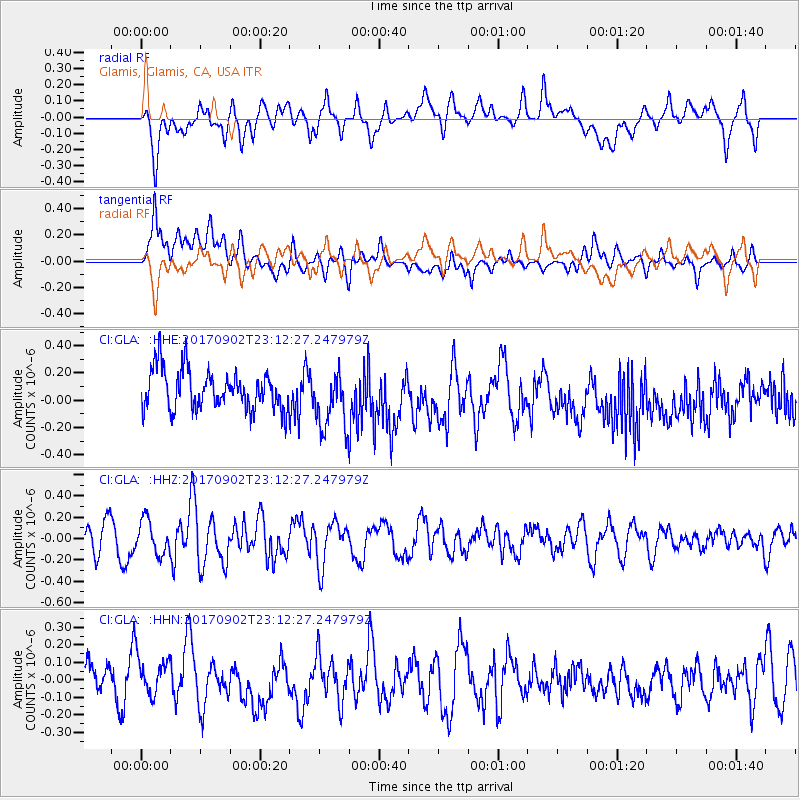
GLA Glamis, Glamis, CA, USA - Earthquake Result Viewer
*The percent match for this event was below the threshold and hence no stack was calculated.
| Earthquake location: |
Mariana Islands |
| Earthquake latitude/longitude: |
14.0/146.7 |
| Earthquake time(UTC): |
2017/09/02 (245) 23:00:01 GMT |
| Earthquake Depth: |
10 km |
| Earthquake Magnitude: |
5.5 mb |
| Earthquake Catalog/Contributor: |
NEIC PDE/us |
|
| Network: |
CI Caltech Regional Seismic Network |
| Station: |
GLA Glamis, Glamis, CA, USA |
| Lat/Lon: |
33.05 N/114.83 W |
| Elevation: |
610 m |
|
| Distance: |
89.4 deg |
| Az: |
56.167 deg |
| Baz: |
286.26 deg |
| Ray Param: |
$rayparam |
*The percent match for this event was below the threshold and hence was not used in the summary stack. |
|
| Radial Match: |
54.19244 % |
| Radial Bump: |
400 |
| Transverse Match: |
58.792435 % |
| Transverse Bump: |
400 |
| SOD ConfigId: |
13570011 |
| Insert Time: |
2019-04-28 16:21:43.585 +0000 |
| GWidth: |
2.5 |
| Max Bumps: |
400 |
| Tol: |
0.001 |
|
Signal To Noise
| Channel | StoN | STA | LTA |
| CI:GLA: :HHZ:20170902T23:12:27.247979Z | 1.4729962 | 1.5717022E-7 | 1.0670103E-7 |
| CI:GLA: :HHN:20170902T23:12:27.247979Z | 1.0251412 | 9.636135E-8 | 9.399812E-8 |
| CI:GLA: :HHE:20170902T23:12:27.247979Z | 1.3221396 | 1.8597217E-7 | 1.4066E-7 |
| Arrivals |
| Ps | |
| PpPs | |
| PsPs/PpSs | |


