You are here: Home > Network List > CN - Canadian National Seismograph Network Stations List
> Station INK INUVIK, NT > Earthquake Result Viewer
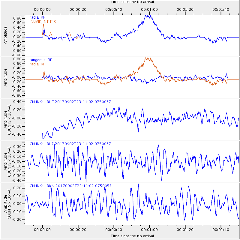
INK INUVIK, NT - Earthquake Result Viewer
*The percent match for this event was below the threshold and hence no stack was calculated.
| Earthquake location: |
Mariana Islands |
| Earthquake latitude/longitude: |
14.0/146.7 |
| Earthquake time(UTC): |
2017/09/02 (245) 23:00:01 GMT |
| Earthquake Depth: |
10 km |
| Earthquake Magnitude: |
5.5 mb |
| Earthquake Catalog/Contributor: |
NEIC PDE/us |
|
| Network: |
CN Canadian National Seismograph Network |
| Station: |
INK INUVIK, NT |
| Lat/Lon: |
68.31 N/133.53 W |
| Elevation: |
44 m |
|
| Distance: |
73.3 deg |
| Az: |
22.459 deg |
| Baz: |
265.805 deg |
| Ray Param: |
$rayparam |
*The percent match for this event was below the threshold and hence was not used in the summary stack. |
|
| Radial Match: |
45.06036 % |
| Radial Bump: |
400 |
| Transverse Match: |
43.5717 % |
| Transverse Bump: |
400 |
| SOD ConfigId: |
13570011 |
| Insert Time: |
2019-04-28 16:22:11.143 +0000 |
| GWidth: |
2.5 |
| Max Bumps: |
400 |
| Tol: |
0.001 |
|
Signal To Noise
| Channel | StoN | STA | LTA |
| CN:INK: :BHZ:20170902T23:11:02.075005Z | 1.3214874 | 1.2402596E-7 | 9.38533E-8 |
| CN:INK: :BHN:20170902T23:11:02.075005Z | 1.3550115 | 1.2030935E-7 | 8.878844E-8 |
| CN:INK: :BHE:20170902T23:11:02.075005Z | 1.8841883 | 2.72266E-7 | 1.4450042E-7 |
| Arrivals |
| Ps | |
| PpPs | |
| PsPs/PpSs | |


